|
Home : Quarterly Archives : Volume 1 |
Tredyffrin Easttown Historical Society |
|
Source: April 1938 Volume 1 Number 3, Pages 9–11 Local titles in Easttown and Tredyffrin: (Continued from Part A)
Plan 7
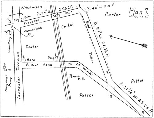
Into Reeseville in 1874, by old Leopard Road and proposed new road.
Sketch made from plan with original road papers. While title into Mrs. Lewis for the greater part of this tract was shown in the January Issue of "The Quarterly", the title to the eastern part between the Llewellyn family's ownership and that of William Neill has yet to be completed. The small portion of the tract shown as in Tredyffrin will not be gone on with at present. By their deed in 1779 recorded in W-l-27, John and Ann Llewellyn conveyed to their brother David their interest in 34 3/4 acres in Easttown-- Beginning at a corner of Thomas William's land in the line of Tredyffrin Township, thence by said land South 26 degrees East 58 perches to a corner, South 38 degrees West 134 perches to a post, North 27 degrees West 40 perches to a black oak, North 35 1/2 degrees East 109 perches to a post, North 8 degrees West 24 perches to the township line and there along 18 perches to beginning. In 1801 Ann Llewellyn convoyed to David by I-2-261, 23 acres of the 66 1/4 acre tract-- Beginning at a black oak, thence by land of James Brown North 27 1/2 degrees West 50 perches to a stone in the Tredyffrin Township line, by said line North 51 1/2 degrees East 106 perches to a stone in the line of land of David Llewellyn, by the same South 8 degrees East 24 perches to a stone and South 35 1/2 degrees Wost 110 perches to beginning. By those two deeds David Llewellyn obtained 23 acres extending to the east as shown in plan 3, and a similarly shaped piece of 34 3/4 acres directly to the south having a northwardly projecting portion 18 perches wide along the township line. He sold the western portion to Alexander Templeton in 1801 by V-2-243, for premises-- Beginning at a post by the Turnpike road, by land of David Llewellyn South 35 degrees East 76 perches to a post in or near a certain road, by land of Whitehead Weatherby South 38 degrees West 43.1 perches to a post a corner, by land of James Brown North 27 1/2 degrees West 90 perches to a stone, by land of John Reese North 51 1/2 degrees East 22 perches to a post, along the Turnpike road North 76 degrees East 8 1/2 perches to beginning. Containing 18 acres and 57 perches. Alexander Templeton and Ann his wife conveyed the tract to James Morris in 1802 by W-2-166, and in 1813 James Morris, Senior, of Easttown, farmer, sold it to William Neill of Tredyffrin, farmer and tobacconist, by I-3-48. Title to the southern portion of this tract following William Neill's ownership has already been shown into Mrs. Lewis. The northern portion passed to Thomas Aiken in 1870 and is treated separately in this issue. To those of our community who come into Berwyn over the Leopard Road and dutifully stop on the steep hill while they size up traffic on the Lincoln Highway, it may be comforting to know that in distance to cover at least, they are better off than when the road crossed the railroad at grade at the old Carter house. From the road, past the old house and barn to the Lancaster Turnpike, past the old Drove Tavern east of the Howellville Road, along the northern side of the railroad and again over the old bridge, east of the Fritz house, it was quite a trip to the center of Reeseville. The course of the old road, long since gone except where it was in the bed of the Lancaster Turnpike, is shown by the accompanying reproduction marked plan 7, from the plan accompanying the original road proceedings at West Chester in Book 108, page 175. The portion of the old road to be vacated and the new one to be opened along the south side of the railroad, and to cross it at the proposed now bridge west of the site of the present upper bridge, and enter the turnpike opposite its intersection with the old road leading to the Widow Howell's Tavern, are also shown on the plan as confirmed by the court May 11, 1874. However, a different course was pursued as will be shown in a later paper, and Tredyffrin has its triple curve from the Howellville Road on to the Lincoln Highway instead of the route shown on the plan. Mr. Pleasants, in his history of Old Saint David's Church, refers to Dr. Henry Y. Carter who is buried at St. David's, as assistant surgeon on Nelson's flagship at the battle of Trafalgar. "IN MEMORY OF HENRY Y. CARTER, M D. Born in London. April 15th 1750 Died November 17the 1849 Aged 99 years & 7 mos. Our Fathers where are they," reads the inscription on his stone. A reference to the plan will show the location of the old Carter house and close to the turnpike, the barn. Mr. F. L. Burns recalls a statement to him by the late Mrs. Joseph W. Sharp that Dr. Carter had lived in the house. Mr. James E. Dawson recalls it as of stone, white, probably two and one-half stories in height and facing south with its west end to the old Leopard Road. It was demolished at the time of straightening the railroad in about 1878. The barn stood at about the site afterwards occupied by the late George Derrickson's auction room and was later to go. |