|
Home : Quarterly Archives : Volume 5 |
Tredyffrin Easttown Historical Society |
|
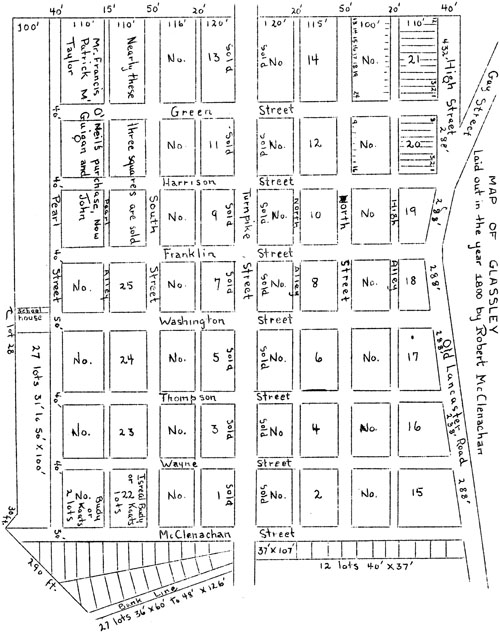
Source: 1943 Volume 5 Number 3, Pages 50–59 The story of the Glassley Commons We are inclined to look upon land speculation as an almost exclusively modern evil, but a glance through a few old deeds taken at random will convince the most skeptical that it commonly occurred in this locality even before the Great Valley received its first settlement, for William Penn's gigantic adventure in real estate offered great possibilities to those disposed to invest. There was none, however, who had the imagination or audacity to plan a town of some two or three thousand inhabitants in our midst until about 1800, when the town of Glassley was actually laid out at about equidistant between the Lamb and Springhouse Taverns in Easttown Township; a town with wide streets, squares and lots, in a parallelogram (irregular only in the eastern outline), approximating 1260 by 2500 feet in extent. Except in minor details, there was nothing unique in this plan. Penn's agents had long since attempted the founding of an inland town under more favorable conditions, in the instance of the Newtown townstead, and had failed. It has since been attempted locally with success, as in the instance of the Paoli Improvement Company, also of the Devon and Wayne developments. On April 13, 14, 1682, there was an original grant of 2000 acres of land to Wood and Sharlow, which extended across the eastern side of Easttown, and on November 23, 1704, William Sharlow, a speculative merchant of London, took as his share 1000 acres lying contiguous to the Radnor and Tredyffrin borders. This he disposed of in one lot, and on 6/6/1740, John Wrightman sold the same to Richard Harrison, who on 12/7/1746, disposed of by will to his son Samuel. The latter, in turn, by will dated 11/21/1770, proven 3/23/1774, left the residue of 780 acres to his sister, Hannah (who had intermarried with Charles Thomson), and to his nieces, Amelia and Mary Harrison. The Harrisons of Herring Creek, Maryland, were people of substance. Richard Harrison, an English Quaker, married in Philadelphia, 1717, Hannah, daughter of Judge Isaac Morris and granddaughter of Deputy Governor Thomas Lloyd. Shortly after their marriage the bridal party were robbed by river pirates of goods and chattels they were bringing north. Isaac Norris gave them the use of his town house for a time. Richard Harrison purchased, 1719, 698 acres of land on the Old Gulph Road in Merion Township, to which he brought his goods and slave. The manor house erected about 1704 by Rowland Ellis and called "Bryn Mawr" after his home in Wales, Harrison renamed "Harriton", which was his own family name with the change of one letter, and here he lived and died in the mansion which has since become one of the most historic and attractive show places along the beautiful Main Line. Charles Thomson received his education in the Academy taught by Rev. Francis Alison at Thunder Hill, Chester County. He is identified as the able and faithful Secretary of the Continental Congress. As a public officer of fifteen years of patriotic endeavor, perhaps the most memorable act of his pen was that of transcribing from the rough draft of Thomas Jefferson the Declaration of Independence. He was twice married, his second wife being the daughter of Richard Harrison, and who was said to have been an aunt of General William Henry Harrison, ninth President of the United States. After Thomson's retirement from public life he composed at "Harriton" a version of the Septuagint, which was said to have been "a worthy landmark of Colonial learning". He died August 16, 1824, aged 95 years. Amelia Harrison married Robert McClenachan who is described as a merchant of Philadelphia. He was a native of Ireland who came to America as a lad and entered the countinghouse of his kinsman Blair McClenachan. Mary married Jonathan Mifflin. On September 18, 1781, Charles Thompson (note the different spelling of his name) and Hannah, his wife, conveyed their third part of the 780 acres in Easttown, to Robert and Amelia McClenachan and to Jonathan Mifflin during his lifetime, and after his death to his daughter Mary (who, dying in her minority, her estate became vested in her aunt Amelia, wife of Robert McClenachan). On 12/30/1815, Robert and Amelia McClenachan deeded all interest in lots in Montgomery County to Charles Thompson, whose wife Hannah had died intestate. In 1800, soon after the completion of the Philadelphia and Lancaster Turnpike through a part of their property, McClenachan planned the town of Glassley, the northern boundary of which was the Old Lancaster Road in part and where it did not front the proposed town, the designer artfully placed a blind avenue leading off from the Old Lancaster Road and called the combination "High" Street, and that part of the Old Lancaster Road running at a tangent, "Gay" Street. The town site extended north and south substantially between the Old Lancaster Road and the present Lincoln Highway; and from and apparently including a part of the old Scott place opposite the present Devon Station, to near Warren Avenue, Berwyn. Running east and west there were High (Old Lancaster Road), North, Turnpike (the backbone of the project), South and Pearl Streets; and running north and south: McClenachan (now Valley Forge Road), Wayne, Thompson (now Fairfield Avenue), Washington, Franklin, Harrison and Green Streets. It will be observed that family connections were honored in the selection of McClenachan, Thompson and Harrison Streets, and Revolutionary patriots in the remainder.
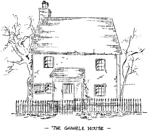
The Gamble House The exact location of the old "Streets" have been followed by few of the present roads. Pearl Alley approximates the present Highland Avenue. Center Avenue lies some fifty or more feet east of Taylor's Lane or Green Street. The western tier of blocks or squares, four in number, was from 210 to 235 by 432 feet in extent, bisected by 20-feet-wide alleys called High, North, South and Pearl Alleys, and the twenty-four smaller squares 210 to 236 by 288 feet in extent. Likewise halved by the continuation of the above-named alleys. The western tier of eight bisected blocks was subdivided into twelve lots, each with 36 feet front and from 110 to 130 feet deep; while the remaining forty-eight bisected blocks were divided into eight lots of about the same dimensions. There were also sixty-six lots 31 to 50 by 100 feet, south of Pearl Street, eleven lots 37 by 40 feet, one lot 37 by 107 feet, and twenty-seven lots from 36 by 60 to 48 by 126 feet, east of McClenachan Street; in all 585 lots. The town plot, of which I present a copy of the original furnished to an investor in 1801, has the unique distinction of being in scale about one-fourth of an inch to the hundred feet lengthwise, and one-half inch to the hundred feet in breadth. A large scale map entitled "Plan of the Town of Glassby" is on file in the office of the Clerk of Courts, Chester County Courthouse. It is in manuscript and lacks McClenachan Street and all the lots east of it. Evidently the name "Glassby" was discarded at an early date. One of the earliest bona fide sales of lots, and perhaps the first dwelling erected after the town was laid out, was that which in later years was known as the Gamble house. An indenture dated July 28, 1801, between Robert McClenachan and his wife Amelia, on one part, and Able (sic) Lewis, joiner, of Tredyffrin, on the other part, in consideration of the sum of $45., conveyed lots nos. 1 and 2, in square 12. This document was drawn up by William Davis, witnessed by Thomas Watkins (weaver), and Sally M'Clenachan. Able Lewis evidently constructed the log house, perhaps with the assistance of Wm. Torbert, another local carpenter, who witnessed the deed drawn up by Whitehead Wetherby, April 2, 1804, when the property was sold to John Lile, Sr., of Upper Merion, for 100 pounds. Later this property changed ownership several times, Francis Clernon sold it, April 9, 1821, to Patrick McGuigan (then pronounced "McGoogan"), and the latter, "late of the town of Glassley", in his last will and testament bearing date of December 28, 1833, and proven February 8, 1840, left it to his widow, Catherine, of the City of Philadelphia, and she sold it to Robert Gamble for $100. This deed was the work of C. Isard, Admr., (presumably of Philadelphia), and the only one of the series not on parchment. Some time after Mrs. Rush Beaumont, nee Gamble, built her new house on the same lots, the log structure was demolished. The records show that Robert McClenachan and Amelia his wife deeded a "Lot of ground being in or adjoining the new Town of Glassley in the township of Easttown-- for the sole use of erecting thereon a building to be used as a schoolhouse for the Tuition of Youth and occasionally for Christian worship forever- " to the trustees, namely, John Smith, Edmund Galagher, John M. Gooden, Benjamin Brown, and Samuel Stark. The consideration was 5 shillings and the date February 2, 1810. (Cf. Deed Book E-3, vol. 53, pg. 321-322.) An interesting account of the old Glassley School on the lot away down at the corner of Pearl and Washington Streets near a spring, has been told by Mrs. Mildred F. Bradley in the Quarterly Vol. I, No. 5, page 13. Just east of the Gamble house there were erected, doubtless at a later date, two stone houses and a small barn. Henry Root occupied one and owned other tracts in Glassley at various times. There were also three small dwellings of stone near the northwest corner of McClenachan Street and the Turnpike, fronting on the latter, occupied in later years by the McKim, McGachey and Stewart families. The log house now known as the Devon Tea House is reputed as dating back to 1734. There is a tradition that it once sheltered the blacksmith or wheelwright who had his shop on the opposite side of the Turnpike, and that it was the home of Patrick McGuigan, the same person who speculated in Glassley lots and who never seemed to have lost faith in the future of the town.
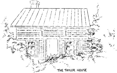
The Taylor House The third house of logs was between South and Pearl Streets, marked upon the town plan as "Nearly three squares are sold, Mr. Francis O'Neil's purchase, Now Patrick M'Guigan and John Taylor". It was reached by a lane opening into the Turnpike and had five gates. the Taylors owned land in Glassley at one time or another in excess of 22 acres, and the log house was occupied by three generations of Taylors: John, Davis, George, until finally the Pennsylvania Railroad purchased it to do away with a dangerous private grade-crossing. The original house is in the process of extreme decay, but, with the spring-house, remains in a pocket formed by the embankments of the Railroad and the new Lincoln Highway, but the barn has been pulled down. McClenachan sold to Watkin Watkins a lot marked No. 4 in Square No. 1, recited 7/3/1802, 368 by 120 feet. This was opposite the Stage Tavern. The lot then passed to Joseph Phillips, 4/2/1810, and John H. Davis, 2/11/1815. Then there was a judgment: Thomas Mifflin vs. John Howard Davis, and Cromwell Pearce, Sheriff, in vendue sold it to Alexander E. Finley, 10/18/1819. Were it permitted, I would hazard a guess that the "Israel Budy or Kaats", who is accredited on the Town map with 7 lots in square 22, but otherwise unknown, was a squatter living in a small log cabin near the easternmost spring. It has been stated elsewhere that the builder of the Stage Coach Tavern is at present unknown. Brooke, in his survey of the Turnpike, published in 1806, shows a section of the road passing through Glassley in which he figures a large building about where the Stage should be situated, and marked it "McClenachan", which points to that gentleman as the probable builder, as he was the owner of the land. The house bears every evidence of being planned for a private residence. Since human nature is what it is and always will be, there can be no question that the project of McClenachan's was ridiculed early and late, Brooke's notation of "Blasted Heath" speaks volumes.
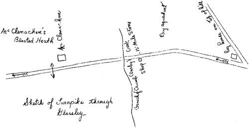
Sketch of Turnpike through Glassley Brooke's sketch also marks a "log house on top of hill". This structure has an interesting story which in a measure fits in with my tale. In 1805 the Great Valley Baptists erected a new meetinghouse and the oak logs of the original building were sold for $55. to George Reese, ex-sheriff of Philadelphia County, who hauled them to the crossing of the Old Welsh or Baptist Road and the Turnpike, just east of the Glassley town, and there refashioned them into a log building in which Jonathan Jones opened a country store, and in which John Lewis (formerly of the Stage) soon after secured a license to keep a public house. The signboard was the work of James McGuigan, who painted a rural landscape with a lamb in the foreground. This was the origin of the Lamb Tavern which enjoyed a good reputation as a wagon stand. Its site is now known as "Roughwood", a private estate. The owner of the Stage Coach Tavern of the Glassley Commons in 1810 was Dr. Havard Davis, and the landlord was John Lewis until 1812 when he removed to the Lamb Tavern. He was succeeded by Edward Robinson, and he in turn, in 1813, by Alexander S. Finley, a Scotch-Irishman, who, after a long tenure, was succeeded by Benjamin Sheneman (1840), a German, who was the last to hold license. The mansion then became the home of Eber Beaumont and his son Theodore and family until it burned down about the close of the century. The town squares of the Stage Tavern tract were between McClenachan and Thompson Streets (eliminating Wayne Street), and eventually including squares Nos. 1, 2, 3, 4, 15 and 16, with the barn on the south side of the Pike. Dr. Sachse states that the sign was the work of that self-taught genius, James McGuigan of Glassley Commons. This sign, swinging from a tall pole, is described as depicting a stage coach drawn by four prancing horses. When the artist died, it is said that Col. Isaac Wayne wrote his obituary, heading it with a quotation from Gray's Elegy. Wayne was a Federalist, and numbered among his militant Scotch-Irish neighbors his staunchest political partisans. Since this model town of Glassley (on paper) was unprovided with a single industry whereby more than a few of its prospective inhabitants could obtain a living, it could not become anything but a failure. The result for many years thereafter was a fenceless tract known as the Glassley Commons, on which the killdeer seemed to have the best claim; for the broad "Streets" became lanes or nonexistent. A writer of a generation ago, following a traditional tale, and unfortunately ignoring source material, stated that the disgusted founder, after disposing of some lots, returned to England and there died intestate. I am unable to learn what relationship Robert McClenachan bore to Blair McClenachan, although Mr. Okie has examined the latter's will and found the former's signature as a witness. Here on the Commons, in after years, Major Benjamin Weatherby, Captain Rowan and Ensign Hampton proudly exercised their militiamen. Later, without leadership, the musters degenerated into a farce when the Commons became the scene of annual "cornstalk" musters of Easttown; when able-bodied men shouldering cornstalks tramped about at random to fulfill the letter of the law. It is related that upon one occasion a hunter came through with a setter dog and someone suggested that they make the dog their captain and the company of privates followed the animal as it quartered about the fields. Some time after Finley assumed charge of the Stage Tavern, it was often referred to as the "Militia House". He had obtained a contract to cart the earth in the local section of the now Philadelphia and Columbia Railroad, and there were long extant many amusing anecdotes of his actions and remarks, some of them unprintable. Although he knew little of military matters, the men called him "Colonel" when he volunteered to load then, and they delighted in repeating his first command: "Line up b'yes, line up wuth your backs to the gum tree and your faces to the turnpike, and stand still until I gov' the word Halt!" A local rustic poet who doubtless had seen better days, but whose name has long since been forgotten, a mere hanger-on about the Stage Tavern, is said to have composed in a comparatively sober moment a clever though crude epigram following an official visit from Samuel Stark, wheelwright by trade opposite the fifteenth milestone on the Glassley Commons, and constable of Easttown by title. We, not being conversant with the nature of the joke, may consider it a rather pointless anecdote conserved by the local historian for no useful purpose; nevertheless there may be an interesting story behind it.
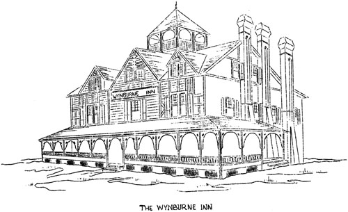
"As Pluto was taking an airing one day, On 10/1/1832, J. Meredith received all parts and parcels in the estate called Glassley which remained unsold, and on 11/4/1840, the Commissioners of Chester County sold for taxes to Alex E. Finley the tracts assessed in the name of John Meredith. Under the date of 12/7/1846, Amelia McClenachan died in the lifetime of her husband, leaving three children: Naomi R., J., and Hannah (who married Wm. Diehl, since deceased), and one grandchild Naomi McClenachan (who married Levi J. Morris), only daughter of Charles McClenachan, eldest son of Robert and Amelia McClenachan. I do not propose to tire the reader with further citations of deeds and other legal documents. It is sufficient to state that in 1851, Joseph C. Smith secured from various sources the greater part of Glassley Commons and united his purchase into a productive dairy farm. When he retired in 1873, during the public sale of his cattle and farm implements, the barn was the scene of the sensational arrest of the leading members of the notorious Hammer Hollow gang of local burglars, at the instance of the Berwyn Protective Association. Some years later the barn was destroyed by fire under suspicious circumstances, and the renter and his son were later convicted of arson under similar conditions in Montgomery County. In 1885 a part of the Smith and Taylor farms was purchased by Charles N. Thorpe, president of the Keystone Watch Case Company, then of Philadelphia, and his wife, Mary Warren Thorpe. They immediately developed that part lying west of the Glassley Commons in the limits of Berwyn, by opening Warren Avenue (the name perpetuates the family name of Mrs. Thorpe), dividing the tract into lots numbered 16 to 28, and erecting five dwellings which were sold and occupied immediately. That portion of land acquired by the Thorpes within Glassley town contained no buildings save the bare walls of the old Smith barn and a shed, (the Smith farmhouse was west of the line), but the substantial walls of the barn were utilised in the construction of a large building, with a frame annex, which in all contained 60 rooms; upon it was bestowed the name of Wynburne Inn (Berwyn turned around).
The Wynburne Inn This building was erected by W. H. Burns for the Thorpes and it became a summer boarding house of varying fortune and changes in management. William W. Downing and wife, who managed it for ten or more years, were perhaps the most successful in catering to the city business man who wished to be with his family and still have them in the country. Later, under another management and under the name of the Lincoln Inn, the building was burned down. Also, within the boundaries of the former Commons John F. Kauffman, C. E., surveyed and plotted large building lots for the Thorpe estate. The lots numbered from 1 to 15. He laid out an avenue (unnamed on the engraved chart, but later called Center Avenue) running from the turnpike to the Railroad crossing opposite the Taylor house; which roadway supplanted and paralleled the old Taylor Lane. He laid out Highland Avenue about where Pearl Alley was supposed to be located, and Fairfield Avenue where Thompson Street was originally projected, a part of which had long existed as a lane west of the Stage Tavern property. Thorpe built his residence on plot number 1 (later the residence of General Fountain), but the era of the automobile had not arrived, and Thorpe's project, like that of the earlier one, was premature. Of the relics of old Glassleytown there remain only two log houses and they are apparently of a pre-McClenachan period. Of the tavern, early schoolhouse and five or six dwellings of the promoter's time there is not a vestige, even the more modern public schoolhouse situated on the south side of the Turnpike, together with the century-and-a-half-old gum tree, have long since disappeared. Who can say whether the mythical town of Glassley as laid upon paper was the conception of a visionary, as so many bubbles of greater or lesser magnitude undoubtedly are, or the misdirected efforts of a shrewd promoter to dispose of a tract of land on the most advantageous terms for himself? We can afford to be charitable, since the financial loss was slight and no one was ruined, and while the local gossips declared that a clear title could no longer be had; their chief grievance was that the land was allowed to grow up in weeds, though they did not disdain to stake out their family cows in the Commons for the pasturage so freely obtained. Glassley did not become a "Ghost" town, for it never existed as a town. In the most depressing period of the "Commons" the wide expanse of nodding daisies, wild carrots or goldenrod, according to their season, recalled no such melancholy sensations as Goldsmith inspired in his "Deserted Village", for Robert McClenachan was merely a century and a half ahead of his time and after so many years of fallow and neglect, the Commons has blossomed like a rose and there are now many beautiful homes within the precincts of the Glassley mirage of long ago. TopReferences Anon. Charles Thomson - The Man of Truth. Northern Constitution (Ireland), May 6, 1939, p. 6. Brooke, Robert. Map of Survey of the Philadelphia and Lancaster Turnpike, 1806. Futhey, J. Smith, and Cope, Gilbert. The History of Chester County, Pa. 1881. Glenn, Thomas Allen. Merion in the Welsh Tract. Norris, J. Parker, Esq. Norris Family - Isaac Norris. Reprinted from The Provincial Councillors of Pennsylvania, 1882. Sachse, Julius F. Wayside Inns. Main Line Times reprint. I am also under obligation to the late Mrs. Rush Beaumont for the loan of deeds and town map; to Mr. and Mrs. William W. Downing for photographs and prospectus; to Miss Dorothy B. Lapp for source material; to Mr. Howard S. Okie for maps, abstracts of wills and deeds, and to Mrs. Laura Schofield and Miss Myrtle Wandless for photographs.
Map of Glassley - laid out in the year 1800 by Robert McClenachan. |