|
Home : Quarterly Archives : Volume 2 |
Tredyffrin Easttown Historical Society |
|
Source: October 1939 Volume 2 Number 4, Pages 90–101 The Old Lancaster or Conestoga Road
Merion Friends' Meeting The partly successful change of name from Old Lancaster to Conestoga Road, which was made some years ago in the eastern part of Chester County, has served at least to keep alive and add interest to the question of the road's name and early history. In spite of its historical importance, however, there seems to have been but little effort to distinguish accurately the story of the old road from that of the Philadelphia and Lancaster Turnpike which succeeded it in many places. The available data is widely scattered through the public records, but enough of it can be brought together to make what is believed to be an understandable picture of an important colonial development, and to remove much of the confusion brought about by several roads leading toward places of the same name, sometimes over the same route and bearing the same or interchangeable names. A considerable portion of the original road had probably been in use by the colonists for upwards of one hundred years when the Philadelphia and Lancaster Turnpike was completed one hundred and forty years or so ago. At that time the earlier name of Conestoga had long since been superseded by the name Lancaster which the road had carried for a generation before the Revolution. It was natural to add the word Old, to distinguish the earlier road from the turnpike and possibly from other roads to Lancaster. The name Conestoga or Conestogoe, and earlier form, justifies fuller discussion and tempts some review of conditions along the Susquehanna and its tributary, the Conestoga Creek, while settlements were pushing westwardly from Philadelphia. The name is that of the Indian tribe referred to in the report of Governor Keith's remarks at Fort George in 1722: "That the Points on which he now came to Treat with the five Nations wore (sic) already communicated to His Excelly & the Council, by his Letter of yesterday. That the first, viz: the Death of an Indian was an accident that might have happened any where, & therefore it was only necessary for him to satisfy the Indians that the Govmt. of Pensilvania was very sorry for it, & had caused the offenders to be put in the Hands of Justice. As to the other Point, viz: That some measures be taken to prevent the five Nations from taking their Warlike Courses through Pensilvania to the Southward, it was the more necessary because the Conestoga Indians were formerly a part of the five Nations called Mingoes, and speak the same Language to this Day; That they actually pay Tribute now to the five Nations, and either from natural affection or Fear are ever under their Influence and Power." Col. Rec. 3, 204. A main village of the Conestogas was included in Penn's Manor of Conestoga, at or near where the creek of that name after crossing Lancaster County from Berks, joins the Susquehanna at Safe Harbor. Conestoga Township, which was organized about 1712 and divided into East and West Conestoga Townships prior to 1719, began at the mouth of Pequea Creek and extended up tho Susquehanna to the mouth of Conestoga Creek, thence up that creek to the mouth of Mill Creek, thence by a direct line to Pequea at the mouth of Beaver Creek and thence down Pequea Creek to its mouth. Rupp's History of Lancaster County, 245. The nearer branch of the Susquehanna rises in New York, in what was once the heart of the Iroquois region. It furnishes an easy route to the valleys of the Conestoga and the lower Susquehanna and it is altogether likely that the Iroquois used it in imposing their will upon the once powerful tribes to the south, and that the colonists preferred their room there to their company. The Conestogas had sold their furs to the Swedes and Dutch long before the coming of the English and had been friendly, and the colonial governors of a later period seen to have spared no pains to keep them so. In the minutes of the Provincial Council of July 15 and 22, 1707, there is an interesting report by Lieutenant Governor Evans of a "Journey among the Indians upon Sasquehannagh". It shows that with eight others, he had set out from New Castle on June 27 and arrived the next morning at Otterarce and reached Pequea that night. And that "On Munday", he: "went to Dekanoagah upon the river Sasquehannagh being about nine miles Distance from Pequehan, where Adjunkoe took a belt in his hands, saying he meant to send it to the five nations for Penn and themselves." Continuing, he said, that on June 30 he was at Pequea and: "On Tuesday, 1st July, we went to Conestogoe, and lay there that night, and the next morning proceeded on our journey, and arrived in the Evening within 3 miles of an Indian Village, called Peixtan." For safety's sake, due to trouble caused by a French Indian trader, they stayed away from the village until next morning, when, after some strategy, they managed to seize him. Then, as the report continues, they: "parted for Turpyhocken; having mounted Nicole upon a horse, and tied his legs under the Belly; we got within a mile of Turpyhocken about 2 of ye Clock, on fryday morning, and about 7 the Govr. went to the town, from thence we went to Manatwny that night, & the next day to Philadelphia."
Col. Rec. 2, 386. There is record of another rapid and important trip. Word had come of the killing of an Indian "at one of their Towns a considerable way above Conestogoe", and on March 7, 1721, James Logan and Colonel French left Philadelphia for Conestoga, met the Sheriff of Chester County on the way and sent him on ahead to make arrests. They arrived in the afternoon of March 9th. Col. Rec. 3; 145. By what route does not appear. The dead Indian was Sawantaeny of the Tsanondowaroonas or Sinnekas, a Warrior, a civil Man of very few words". The Senecas were a tribe of the Five Nations and prompt measures were advisable. The persons responsible were brought to Philadelphia for trial, the usual gifts made to the Indians, accompanied by stately speeches from each side, referring at length to their great and good brother William Perm, of whom the governor was the natural successor, endowed with all attributes, and the trouble smoothed over. This was the usual procedure; with the Indians, on occasion, even professing to see in the son and grandson, the greatness and goodness of the man whom they honored, and whom Civility and other important warriors had seen. They were by no means guileless. One of them remarking after a complaint against the supplying of rum to the tribe, that it might be just as well not to press this. For, said he, without the rum, their fur trade would go to Maryland. Later, at the request of the Indians, the white men were freed. Other contacts with the Susquehanna and Conestoga regions than those of the fur trade, developed rapidly. In 1709, there began the great German migration of the Palatinate into the sparsely settled western part of Chester County, which became Lancaster County in 1729. In 1718, was the beginning of the exodus of many of the Welsh settlers of the Welsh Tract, to the comparatively unexplored territory north of Conestoga Creek in the northeastern part of the present Lancaster County. History of Old St. David's Church by Henry Pleasants, 73. Other settlers came in smaller groups. Soon, the name Conestoga began to come into general use as a popular name, including that of a number of roads. In 1718, on the west side of Conestoga Creek, there was founded the City of Lancaster, called Hickory Town until 1730. Possibly, if the importance to which it was to grow had been realized, it too would have borne the proud and popular name of Conestoga. This general application of the name has applied somewhat to the region along the Conestoga Creek, and early references to Conestoga as a place may be somewhat varied in location. It is even used at this time to indicate a group of modern houses along the old road in Delaware County.
Haverford Friends' Meeting on Eagle Road, south of Haverford Road 1/4 mile, in Haverford Township, Delaware County Meanwhile, the colonists near the Delaware and the Schuylkill had of necessity, opened and used the eastern portion of the road through the Welsh settlements in Merion and Radnor which it had served since about the time of Penn's arrival, and thence westwardly into the present Chester County. Eastwardly, it must have already extended to tho Upper or the Middle ferry over the Schuylkill, or to them both. In 1687, tho Provincial Council gave attention to a petition by residents of Radnor: "Complayning yt part of ye road yt leads thence to the ferry of Philadelphia is ffenced in, & More likely to be". and appointed viewers - "to view or agree upon, as Conveniently as may be, a Road from ye Place aforesaid to ye ferry, and ye Like Convenient Road from Darby to ye ferry aforesaid". Col. Rec. 1, 209. A distinction is thus made between the road from Radnor and the Darby Road. In 1693, Philip England, who claimed that by an order dated "16th of 8 ber, 1683", he had been authorized "to keep an Ordinarie and ferrie at Skuillkill", succeeded in having William Powell and Nathaniel Mullinax stopped from ferrying at Powell's ground. Col. Roc. 1, 387, 437. Later, at a council held September 30, 1706, Col. Roc. 2, 276, the petition of numerous residents of Merion was presented, requesting permission to set up another ferry over the Schuylkill: "between the lands of Edwd. Roberts on the further side, & Thos. Shute on the hither side, to be kept by the said Robt., and that a road should be laid out from Meirion mooting house to the said ffery, & from thence falling into the Road leading to Philadelphia."
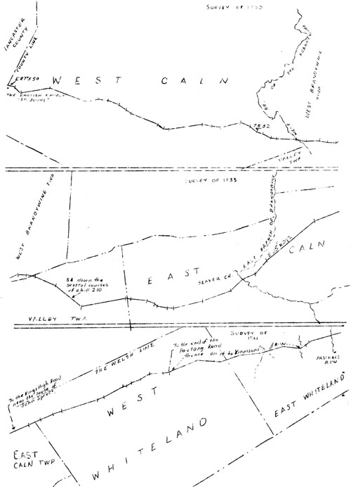
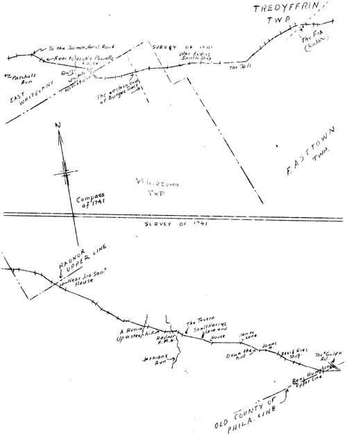
Radnor Friends' Meeting on Old Lancaster Road near "German's Run" or Ithan Creek in Radnor Township, Delaware County The petition was denied on the ground that adequate service was already supplied by John Powel's "upper ffery". As to the proposed new road, which was said to be fifty-one perches shorter than the road by Powell's ferry, it was said that the County Court might act as it saw fit. Col. Rcc. 2, 289. At this time, such courts had limited jurisdiction as to the laying out of roads. Great roads, or the King's highways, were under the control of the Governor and Council alone, but not the lesser roads. The needs of the early settlers in the neighborhood of Philadelphia, seem to have caused this part of the road to take a rather circuitous course which was unnecessary further west. Except for comparatively minor divergences of which there are plenty and which indicate that the original surveys followed the road, as already in use, we shall, now see it headed straight for Conestoga by way of Thomas Moore's mill on the east branch of the Brandywine, at what is now Downingtown. Unfortunately, the earliest records of the road's course can not be found and the dates either of actual or official opening are not known. There was, however, in 1718, a petition to the Council by residents of and near Conestoga, for a road, from that place to Thomas Moore's Mill and Brandywine. Col. Rec. 5, 43. This suggests that it had already been officially opened from Philadelphia to the Brandywine. That in 1721 the road had already been formally laid out eastwardly to the Brandywine, and was in actual use from that point to Conestoga, is shown conclusively by proceedings in that year, relating to the laying out by the Chester County Court of a road between the Great Rood at Owen Perkins' plantation in Tredyffrin and the head of the west branch of the Brandywine; said by opponents of the road to be "quite up to the Pallatine Settlements on this side Conestoge". It was contended by persons obviously interested in the road from Philadelphia to Conestoga by way of Moore's Mill, that the Court had exceeded its jurisdiction, and the Council ordered: "That the Road now and heretofore used loading from Philadelphia to Conestogoe; through the townships of Merion and Radnor, and laid out by the authority of this Government as far as Thomas Moore's Mill, on Brandy Wine River or Creek, be deemed the King's Highway and public Road, And that all former Orders of the Justices of the said County, for laying out and clearing the said new Road now complained of by the Petitioners be for the present Superseded". Col. Rec. 3, 142; Original Road Papers of Chester County 1, 128, 136. Two years later Thomas Smidley and George Aston were to be allowed at their own cost, to alter part of the road passing through their lands "near Thomas Moores Mill in Chester County", Col. Rec. 3, 227, and in 1726 a tavern license on the Great Road from Philadelphia to Conestogoe, was to be granted to George Aston of Cain Township. Chester County Tavern Licenses, 1, 133. In 1724, after hearing the persons interested and David Llewellyn, the surveyor who had laid out two courses of a road which it was proposed to open from William Paschall's land on the Great Conestogoe Road in Whiteland to the Swedes Ford over the Schuylkill, the Council decided in favor of the southerly route as more convenient for the public and for the congregation of Baptists and ordered it to be opened. Col. Rec. 3, 225, 230, 231. This was the Swedesford Road and the Baptists those or the Great Valley Baptist Church. The courses of this road were corrected and the beginning point officially fixed by a later report, April 15, 1725, as at a remarkable stone in the Conestoga Road between the houses of William Paschall and Isaac Maylin, near a cornor of the latter's field lane. In 1726, the Chester County Court directed the laying out of a road appearing in the records as "Road from Conistogoe to Whiteland", beginning at a water beech tree standing on the east side of Conestogoe Creek about twenty perches below the forks thereof, and ending at a white oak tree standing by the Philadelphia Road on the land of John Spruce: Chester County Original Road Papers, 2, 6. In opposition proceedings which developed, this road is said to be through the Township of Pequea from near Thomas Moore's toward the Township of Donegal. Col. Rec. 3, 265. On January 29, 1730, a petition of the magistrates, grand jury and other inhabitants of Lancaster County and others, was received by the Council. It stated broadly, with evident reference to King's highways: "That there are no public roads leading to Philadelphia yet laid out thro' thoir County, and those in Chester County, thro' which they now pass, are in many places incommodious." Col. Rec. 3, 394. A view of the portion of the road in Lancaster County was requested and a review of the Chester County part. The petition having been granted and viewers and reviewers appointed, a return was made in 1733, laying out the road from the Court House in Lancaster to the King's High Road leading to Philadelphia near the house of John Spruce. It states further that being unprovided with a copy of the road through Chester County and the lands contiguous to the road being mostly improved and under corn, the viewers found themselves: "uncapable to discover where the same hath been altered from its true course, (to the Damage thereof,) and also conclude the present Season of the year Improper for a Review." The return was confirmed and the road "declared to be the King's Highway or Publick Road" and to be "cleared and rendered commodious for the Public Service". It was also directed that the "same persons of Chester County, who have already laid out the Road so far as in the above Return is mentioned, be continued on that service to bring the Road to the verge of Philadelphia County", and that from that point it be continued "to the Ferry aforesaid at High Street". The courses and distances of the survey of the road from Lancaster to near the house of John Spruce may be traced on the accompanying plan. The words "degrees" and "perches" being omitted in each case: From the Court House in Lancaster along the course of the street, E 3 N 144, E S N 108, E 16 S 282 to East side of Conestoga Creek, E 5 S 25, 3 10 N 190, E 6 S 1271, E 4 S 696, E 10 N 90, E 74, E 6 S 820, E 13 N 80, E 6 S 406, E 8 S 94, E 6 S 80, E 32 S 118, E 13 S 160, E 364, E 19 S 490, S 41 E 40, E 27 S 68 to the aforesaid division line near the English Church, and then through Chester County E 27 S 50, E 51 S 54, E 5 N 188, E 25 S 246, E 7 N 80, E 10 S 60, E 25 S 74, S 38 S 48, S 44 E 42, E 25 S 190, S 35 S 48, E 15 S 32, E 5 N 216, E 17 S 60, E 13 S 60, E 10 N 130, E 26 S 60, S E 52, S 26 E 40, E 35 S 56, E 15 S 36, E 5 S 121 to the West Branch of Brandywine Creek, E 26 S 41, E 8 S 32, E 82, E 17 S 46, E 8 S 58, E 20 N 72, E 5 S 54, E 15 S 54, E 30 S 146, then East Southerly down the several courses of a hill 210, thence E 5 N 288, E 13 S 30, E 11 S 100, E 26 S 56, S 51 S 20, E15 S66, E 10 S 42, E 10 N 194, E 15 N 188, S 4 0 N 100 to the East Branch of Brandywine Creek, near Thomas Moore's Mill, E 17 N 86, E 43 N 114, E 35 N 392, E 16 N 216 to the aforesaid public road, (Inserted: the King's High Road leading to Philadelphia) near the house of John Spruce, containing in the whole 32 statute miles. Col. Rec. 3, 522. While these efforts were under way, a petition of residents of Chester and Lancaster Counties had been *iled (sic), setting forth the need of a high road in the remote parts of the two counties and reciting: "that a very commodious one may be laid out from the ferry of John Harris, on Susquehannah, to fall in with the High Road leading from Lancaster Town, at or near the Plantation of Sdward Kennison, in the greet (sic) Valley in the County of Chester." Col. Rec. 4, 181. The Lancaster Countians, on November 26, 1739, made another attempt for a better road from Spruce's land to Philadelphia, by another petition for review, alleging continued neglect of the road by the township authorities from Whiteland eastwardly, under the pretense that it had never been recorded. Reference to this is found in the History of the Philadelphia and Lancaster Turnpike by Charles I. Landis. It tallies with the apparent absence up to 1711, of a recorded survey for the eastern half of the road. Final and complete action was to come at last. On April 6, 1741, there was a petition to the Council from residents of Philadelphia, Chester, and Lancaster Counties; reciting the order laying out the high road from the town of Lancaster to High Street Ferry at the west end of Philadelphia City in 1733; the laying out in that year of the road from Lancaster, through Lancaster County and part of Chester County to the plantation of John Spruce; the fact that further execution of the order laying out the remaining portion of the road had, for causes unknown, been deferred; and requesting appointment of viewers to lay the road out from Spruce's land to the ferry at Philadelphia. The petition was granted, the viewers' return confirmed and the road ordered cleared and opened. Col. Rec. 4, 495, 503; Chester County Road Docket A, 82. The route follows: "July 20th, 1741, Conestogo (sic) Road Surveyed: "Beginning at the end of John Spruce's land and extending thence within the Township of Whiteland in Chester County, N 72 E 120, N 70½ E 80, N 74 E 90, N 78 E 56, N 81 E 240, N 72 E 40, N 69 E 84, N 65 S 48, E 20, N 69, E 40, N 73 E 62, N 69 E 66, S 88 E 88, S 77 36 to the end of Paxton Road, then on it to Kinnison's Run, Beginning at the run thence N 62 E 40, N 54½ E 40, N 82 E 134 to Paschal's Run, N 88 E 54, S 85 E 58, E 96 to Swedes ford Road, S 53 E 66 to a chestnut tree, S 44 E 22 near to Robert Powell's house, then leaving the old Road and on George Aston's land S 72 E (at 200 perches a run) at 280 perches the old Road, then on it S 33½ E 24, then In Willistown S 32½ E 20, S 35 E 31, S 86 E 60, S 89 E 60, N 84 E 40, N 79 E (at 78 perches the western line of Burge's tract we continue to) 86 perches, N 83 E 90, S 82 E 124, N 872 E 96 (about 6 perches further is William Evans' Smiths' Shop), then in Tredyffrin Township N 86 E 34, S 85 E 64, S 75½ E 62 S 81 E 56, S 86 E 166 perches to the Sign of the Ball, N 58 E 128, N 62½ E 34, N 56½ E 30, N 70 E 84, N 67 E 68, N 73 2 S 34, S 87 E at 42 perches entered East Town continued in it to 62 perches and then S 74½ E 40, S 81 E 28, N 84 E 102, S 74 E at 60 perches a line of Tredyffrin and in it to 80 perches and then in East Town S 88 E 34, S 70 E 86, S 63 E 50, S 46 E 70, S 54 S (at 25 perches Radnor upper line and continued in it to 55 perches which is near Jno. Sam s House), S 52 E 46, S 57 E 184, S E 28, S 28 E 40, S 55½ E 46, S 51 E 64, S 52 E 48, S 81 E 30, S 63 E 104 to a run, then up a steep hill S 78 E 20, S 62 E 110, S 87 E, at 28 perches Radnor Meeting House, at 48 perches Germans Run continued to 70 perches, then S 53 E 14, S 42 E 26, S 70 E at 20 perches the Tavern at 130 perches to Samuel Harry's Lane End, S 59½ E at 60 perches to his house, S 81 E 186 perches to James's Lane End, S 62 E 66, S 54 E 58 perches down the hill, S 85 E 44 perches the house 10 perches on the left, S 63 S 72 to the county line of the width of fifty feet, (the description varying very slightly from that in the Colonial Records, is at West Chester down to this point.) then from Radnor line in Merion Township, S 45 E 48, S 63 E 140, at 6 perches David Rios' Shop, thon the County of Chester line, then S 65½ E 112 perches to Benjamin Humphrey's upper line, being the County of Philadelphia line, S 82 E 104 perches, the "Gulf" Mill Road, S 63 E 36, S 49 E 48, S 39 E 48 to Benjamin Humphrey's line, then on Edward Humphrey's land S 51 S 144, at 102 perches Richard Hugh's upper line, at 134 perches his house, S 81 S 120, S 64 E 38, N 66½ E 76, N 41 E 58, N 71 E 52, S 86 E 88, S 64½ E 22, S 55 E 27 perches to Evan Jono's lower line, S 60 E 136, S 56 3 C4 perches, at 10 perches Merion Meeting House, S 75 E 38, S 63½ E 72 perches at the "fford Road", S 78 E 66, S 41½ E 58 perches at 48 perches Richard George's upper line, S 23½ E 82 perches, at 61 perches Richard Goorge's lower line, S 33 S 106 perches to Blockley line, S 24 E 42, S 6 W 73 perches, Edward George's upper line, S 10 E 208 perches, at 136 perches the lane to Edward Goorge's house, at 166 perches David George's lane, S 24 S 84 perches, David George's Run, S 45½ E 550 perches to Haverford Road, S 52 E 294 perches to Peter Gardner's house, and then S 74 E 100 perches to high water mark at the end of the causeway at the west side of High Street Ferry.
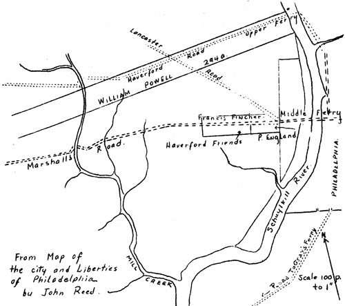
From map of the city and Liberties of Philadelphia by John Reed Perches Reduced to Feet |