|
Home : Quarterly Archives : Volume 3 |
Tredyffrin Easttown Historical Society |
|
Source: January 1940 Volume 3 Number 1, Pages 13–21 The old Lancaster or Conestoga Road
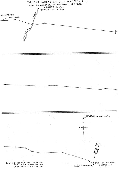
The Old Lancaster or Conestoga Rd. from Lancaster to present Chester County Line Survey of 1733
From the Old Philadelphia County Line to the Schuylkill River Survey of 1741 and from the Schuylkill to the Delaware
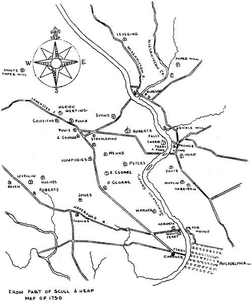
From part of Scull & Head Map of 1750
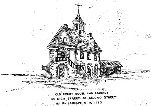
Old Court House and Market on High Street at Second Street in Philadelphia in 1710 Continued from the November issue. From the Delaware to the Old Philadelphia, County Line In 1693, as has been mentioned, Philip England claimed that he had been authorized by Penn in 1683, to operate a ferry across the Schuylkill, and in Scharf and Wescott's History of Philadelphia, page 120, there is reference to the provision of the Council in 1685, for a ferry at High Street, large enough for horses and cattle, indication of rapid growth of the settlements west of the river. The early settlers in Blockley and Merion must have been among the first to use the straight road from a point some distance west of the
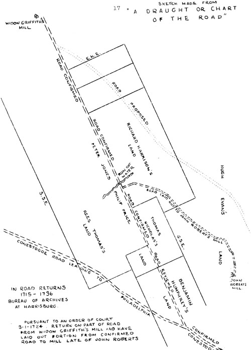
Sketch made from a draught or chart of the road; In road returns 1715-1736 Bureau of Archives at Harrisburg Schuylkill to the old court house near Second Street. It has been said, Scharf and Westcott, page 10, that the Darby Road may have crossed the Schuylkill at this ferry before its crossing at Grays Ferry. "Possibly the road was used in some form before the coming of Penn but any crossing before that time would have been elsewhere than at this deep part of the river where the Middle or High Street Ferry was afterward built. The earliest use of the road from Thirty Second Street eastwardly was, therefore, not exclusively as a part of the Darby Road, the original course of which probably was not in this direction. Scull and Heap's Map of Philadelphia and Parts Adjacent - 1750, shows no lack of early routes. That, according to present names, by Fifty Fourth Street, from City Line to Lancaster Avenue and along it and Market Street to the bridge, is the course shown by the survey of 1741 and usually associated with the Old Lancaster Road, and the use of the eastern part must date from the operation of the ferry. It is likely, however, that the earliest travelers between Philadelphia and Merion crossed the river at a ford, possibly following the trails of the Indians and Swedes; but whichever of the several available ways was used first, the High Street way by Middle Ferry and the present Lancaster Avenue, became the main route at a very early date. Within the present City Limits, just to the west of the World War Memorial on Fifty Fourth Street, one of the old mile stones is still to be seen. It bears the numeral "6", as the number of miles from the old court house, and a tablet inscribed: "original mile stone - marking Old Lancaster Road or Blockley and Merion Turnpike laid out in 1690 Tablet erected by Merion Chapter D. A. R. 1917" Only a year before, Penn had written in his "Instructions for Lt Governor Blackwell or whome else It may Conserne": "11. That Care be taken of ye Roads and Highways In ye Country, that they be straight and Commodious ffor Travellers; ffor I vnderstand that they are turned about by ye planters, wch is a mischief yt must not be endured." Col. Rec. 1, 318. Several years later, on December 19, 1693, there was a petition to the Council by inhabitants of Radnor-- "requesting a road to be laid out from the upper part of the said Township of Radnor into Marion ford, and of Andrew Robeson and Lawrence Esquire's requesting a confirmation of the Road that now is from Marion ford to Philadelphia and that it come into the Third Street in the said" The roads were ordered to be laid out. Philadelphia Road Docket 1-26. There need be no disagreement with the Proprietor's complaint and reference has been made to the fencing in of a road from Radnor "to the ferry of Philadelphia", but despite the practices of the Colonists and the lack of very early surveys, the oldest part of the road as known, except for minor divergences, mainly in the vicinity of Fifty Second Street, is in use today to west of Berwyn. Here, a mile or so of the road was abandoned many years ago. From the site of the old court house beside the Delaware, along Market Street to the Schuylkill, there is little resemblance to early scenes when the first ferry was built. Westwardly, the road extended to Thirty Second Street, passing the Schuylkill or Haverford Friends' Meeting and the graveyard. Just before reaching Thirty Second Street was Peter Gardner's house, one hundred perches from high water mark at the end of the ferry causeway, according to the survey. From Thirty Second Street it turned northwestwardly, crossing Haverford Road just to the east of Fortieth Street and equidistant from the Middle and the Upper Ferry. Continuing substantially straight on to a little to the west of Fifty Second Street, it crossed "David Georges Run", which while not to be seen now is probably still on its way, underground, to Cobbs Creek. Then it led up the long hill on Fifty Fourth Street, to the Blockley and Merion Township line, now known as City Line, passing on the way the sites of the former David and Edward George, and Humphries houses. The course of the road in this neighborhood has been altered in part for many years by Pennsylvania Railroad developments. Lancaster Avenue, or Lincoln Highway, now extends on the south side of the railroad, to Overbrook, and the old road is to be found by following Jefferson Street from Fifty Second, under the tracks of the Schuylkill Division of the railroad.
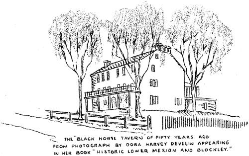
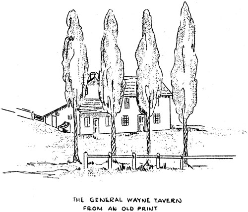
The 'Black Horse Tavern' of fifty years ago from photograph by Dora Harvey Develin appearing in her book 'Historic Lower Merion and Blockley.' The old Black Horse Tavern, an American outpost and scene of a skirmish during the British occupation of Philadelphia, stood on the northwest corner of Old Lancaster Road and City Line Avenue. Further along was the old homestead of the Latch family, the name of which is given to Latch's Lane and appropriately mentioned here, since Jacob Latch is credited by reliable family tradition with the exploit of hampering the operations of the British by cutting the ropes at the ferry. At Merionville the old road is joined by Montgomery Avenue which follows it to Haverford. Several more milestones may be seen along this section of the road which is also occupied by the very old Gulph Road. Next, to the west, was the "fford road" mentioned in the survey of 1741 and leading to the Schuylkill. A little further on, also on the north, is the old General Wayne Hotel, part of which, it is said by Charles H. Browning in his book, "The Welsh Settlement of Pennsylvania," must have been built soon after the nearby meeting house. It is said to have been named for General Wayne on his return from his successful campaign against the Indians. At about this point in the survey as printed, is the course of south seventy-five degrees east thirty-eight perches. It would seem that this course is included in error and that it should be disregarded. Next is the Merion Meeting House, probably built in or about 1695 and succeeding an earlier log building. It is one of the oldest houses of worship in Pennsylvania still standing, and is remarkable also for its unique style of architecture, entirely out of accord with that of the usual Friends' meeting house. In this neighborhood, evidences on the ground of the old Philadelphia and Columbia Railroad, predecessor of the present "Main Line" must still be recalled by the older residents, and users of the old road of less than a generation ago will recall the toll gates which had not been in use a great while. But to continue in detail at this time, would be to detract from the history of the road itself and to repeat much of what is mentioned in the survey and described in Mr. Browning's book dealing exhaustively with this historic region. At Haverford, immediately opposite the Cassatt Memorial, Montgomery Avenue diverges to the right from the old road which continues its rather tortuous coarse toward Radnor Meeting, passing under the railroad tracks several hundred yards west of the station. After a short deviation at the railroad, it soon crosses the turnpike and leaves Lower Merion Township at the old Philadelphia and Chester County line, near the northwest corner of Haverford Township. This is the first contact of the two roads since their separation at Fifty Second Street. The next will be near the western boundary of Delaware County, where they merge for a short distance between Wayne and Strafford. The roads join four times between Fifty Second Street and Paoli, but their course is common for hardly half a mile in all. The difference in origin appears in their courses. The purpose of the eastern portion of the older road was to accommodate the earliest colonists and their growing settlements. The turnpike, on the other hand, was designed to afford communication between Philadelphia and Lancaster as expeditiously as possible. Each served its particular purpose, but it is along the older road that the earlier buildings and points of greater historic interest are to be found. Comparatively few of the houses along the turnpike as far west as Paoli antedate its construction, except in the few instances of where the two roads are in the same place. The construction of the turnpike brought about a great reduction in the use of the old road and caused its inns to close, but it has profited in a manner and to a degree which could not have been foreseen. Unlike the road by which it was supplanted as the great road of the day, it is unmarred by modern highway conditions and remains a beautiful and historic way from west of Berwyn, through Merion Meeting and Fairmount Park to the Philadelphia Parkway, capable of variation to Montgomery Avenue, by continuing north of the highway from Devon, along Upper Gulph Road, instead of by the southern way by Radnor Meeting. To be continued
The General Wayne Tavern from an old print |