|
Home : Quarterly Archives : Volume 6 |
Tredyffrin Easttown Historical Society |
|
Source: 1944 Volume 6 Number 1, Pages 10–22 The Thomas Jarman's Mill Road A primitive road of 1710, without known courses and distances, and marked only by notches on the trees, leading through the forest from Thomas Jarman's Mill in the Great Valley, down Darby Creek to the great road to Philadelphia near the old Radnor Hunt. What a free-for-all controversy arose over efforts to change its course from what is now Berwyn to the present Sugartown Road! It is with this section of the road and its very early branch, tho Newtown Road, each forming an annoying junction with Sugartown Road, and with the names, at least, of the persons who took part in the contest, that this account is mainly concerned. In the year named, grand jurymen Lewis Lewis, David Thomas, William Lewis, Richard Miles, John Morgan, and Caleb Evans made return to the Court of a road - Beginning at Thomas Jarman!s Mill in the Great Valley thence to a white oak on said Jarman's land marked with five notches thence through land of John Mordent to a marked poplar with five notches thence through land of John David to a marked chestnut thence through land of John David to a marked chestnut oak thence "to a chestnut standing of tho road side leading from the Great Valley to Philadelphia" all marked with five notches as aforesaid, through land of Lewis Walker to a black oak marked with five notches through land of Philip David and through his field to a white oak thence through land of Edward Hugh in Easttown and so along between his house and his barn to a white oak on the said Edward land marked with five notches thence to a hickory marked with five notches on land of Aaron Roberts thence to a black oak marked as aforesaid on the land of Morgan Hugh thence to a marked black oak on land of Richard Miles thence to a marked black oak on land of William Sharlow so called thence to a marked black oak on land of Jeremiah Jarman thence to a Spanish oak on land of John Langyworthy all marked with five notches as aforesaid through land of Caleb Evans and between his orchard and his meadow and by his house and through land of John Lloyd and Richard Cook to a marked black oak to a marked hickory on land of Evan Evans and so along to William Davis's mill in Radnor to a marked hickory on land of Richard Iddings to a marked black oak on land of Thomas Thomas to a marked white oak on Ruth Miles land through land of John Meredith and by his house to a marked white oak on his land to a black oak on land of Joseph Jones all marked with five notches as aforesaid and so into the Great Road leading from Radnor to Philadelphia. These proceedings appear in the first volume of the Old Court Records of Chester County, page 200. Other proceedings relating to the Jarman's Mill Road controversy are in Volume 11 of tho Original Road Papers, Page 17. The story of Thomas Jarman's mill on the north or main branch of Valley Creek, across the farm of the late Dr. Jacob Rickabaugh from Valley Presbyterian Church, appears in this issue of The Quarterly, and nothing can be added here to Mr. Burns' interesting account of this old landmark. Mordent's ground mentioned in the description of the road was to the east of that of Jarman, and east of Mordent was land of Davis or David at or near what is now Howellville. The earlier road joined by the road of 1710 and referred to as "leading from the Great Valley to Philadelphia" seems to have been the Swedesford. At the top of the South Valley hill, lying along the line between Easttown and Tredyffrin Townships, was the 250-acre tract of Lewis Walker, and adjoining Walker's land on the south was the 500-acre tract acquired by Howell James in 1690 and sold in 1703 to Edward Hugh or Hughes, who in the same year had sold 100 acres along the north line to his brother-in- law, Philip Davies. These tracts extended on the west to what is known as the Welsh Line which is a little to the west of Walnut Avenue in Berwyn, and continues southward to Newtown Road at its junction with Sugartown Road and along the former toward Newtown Square. Northward from Berwyn the line seems to have continued to the Swedes ford Road near the point it crosses the Chester Valley Railroad. The valuable plan appearing in the Road Papers, and reproduced here shows the original road to have been close to the present intersection of Conestoga, Lancaster, or Old Lancaster Road with Howellville Road, and to have slanted across what is now Berwyn to a point south of Waterloo Road. Thence it continued on the lower ground near the east line of the William M. Coates property to the former Davies and Hughes properties and between Edward Hugh's "house and his barn". The steep Waters' Hill was thus passed by and the line of Sugartown Road reached near where Church Road now joins it just east of Darby Creek, Church Road having been moved to this point within recent years, from its earlier location at the Tarleton oak. The ground shown on the plan as that of the widow Llewelling or Llewellyn was part of the original Lewis Walker tract. Land of the Widow James was formerly that of Edward Hugh. Continuing south along the western boundaries of these properties the Welsh Line divided the lands of John Morris and James Scott. With the aid of Smith's atlas of early grants and patents in Delaware County, the line of the road can be traced through Delaware County with some degree of accuracy, down Darby Creek to the junction with Goshen Road near the old Radnor Hunt. In 1716 the Newtown Road was opened along the Welsh Line from the line of Sugartown Road into Delaware County. With its connection with the road of 1710 a short distance to the cast it soon surpassed the older branch of the road in importance, as it does today. The first reference to Newtown Road which has appeared is in Volume 1 of the Original Road Papers, page 74, where will be found the petition of Lewelin David, James Parry, Thomas David, Rowland Richard, John David Howel, Evan Bowen, Stephen Evans, Griffith Jones, David Jones, John David, Griffith Jones, Haei (?) Jones, Thomas Martin, Thomas Roberts, John Roberts, James Abraham, James David, Owen Gothing, John David Thomas, Evan Jones, Thomas James, Thomas Rees, Philip David, Edward Hugh, David Davis, John Hary, Hugh Howel, Richard Miles, John Morgan, and Caleb Evans, reciting that they have no road from their places of habitation to Newtown Road that loads to Chester and also to Richard Hays' mill, and asking for relief. On March 29, 1716, the Court appointed Samuel Williamson, Evan Lewis, William Lewis, Thomas Edwards, Lewis Reece and Hugh Jones to lay out a road from Thomas Jarman's Mill Road to the Great Road loading to Newtown Meeting House. Some months later the report was made and confirmed by the Court, and the road directed to be laid out 40 feet wide. On May 26, 1767, there appears the petition of Isaac Wayne, Griffith Williams, James Davis, Benjamin Hampton, Benjamin Bartholomew, Israel Davis, Anthony Pritchard and David Lloyd, stating, with reference to the road loading "from Thomas Jarman's Mill Road to the Road that leads to Newtown Meeting House", that the order of the Court of Quarter Sessions of May Term 1716, under which the road was opened and had been used constantly ever since, had not been recorded. The Court thereupon ordered recording and declared the road to be opened of the width of 40 feet - Beginning at a marked hickory by Thomas Jarman's Mill Road in land of Edward Hughs, S 40 W upon said Hugh's land 10* to a hickory sapling marked, W 8 S on the same land 16 to a marked hickory sapling by line of land laid out for William Sharlow, S 24 E on line between said Sharlow and lands of Edward Hughs, David Thomas, Morgan Hughs and Owen Humphrey 380 to a black oak marked being a corner of land of Lewis Roes, S 24 E on the dividing line between Lewis Rees and lands of Henry Lewis, Wm. Thomas and James Price 140 to a marked poplar tree "in road that from the valy to Newtown Meeting House." Next, there was in 1726 the petition of Anthony and Francis Wayne, Owen Hughes, Ellis Pugh, Samuel Owen, Thomas David, William and Richard Evans, William Thomon (sic), Nicholas White, Morris Griffith, Marck Hobert, Griffith Jones, James David and Griffith Howell requesting the laying out of a road from the road formerly laid out by order of Court to Newtown, "to load to our place of worship in the Church of England at Radnor", to branch out of Newtown Road near Anthony Wayne's plantation, from the road leading to Evan Hughes' plantation to another road which was formerly laid out by order of Court, which last road loads to the Church at Radnor. William Lewis, George Ashbridge, Richard Jonos, Lewis Reece, John Williamson and John Hunter being appointed to view, made return that they had laid out a road "for the use of Radnor Church so called": Beginning and branching out of the Great Road "leading from Great Valley down through Nowtown (viz) at a Spanish oak where a road used for several years branches therefrom and thence S 89 E 80 to a white oak, S 67 E 96 to a post dividing the lands of Owen Hughs and Benjamin Ellis, along this line S 26 E 44 to a post, N 81 E 187 to a black oak dividing the lands of Benjamin Ellis and William Sharlow, S 77 E 246 to a black oak sapling in Evan Hughs land and thence meeting another road formerly laid out to the Church. The road was allowed and ordered to be recorded. *Note: Degrees and perches are to be understood in road descriptions. A perch is 16- 1/2 feet. It will be understood also that the exact wording of the old proceedings is used in many cases in the text although not marked as quoted.
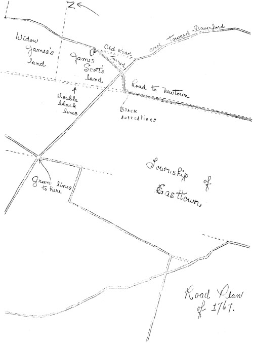
Road Plan of 1767
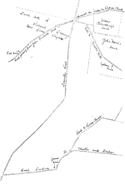
Road Plan of 1767 Thus, as early as 1726, three roads had been developed at the point in Easttown now known as Signal Kill, site of the encounter between Light House Harry Lee and Major Tarleton of the British Army; 1. The Jarman's Mill Road of 1710, running southeastward from Chester Valley; 2. The Newtown Road of 1716, erroneously reformed to as fcho groat (sic) road from the Valley to Newtown; 3. The road of 1726, attending toward St. David's Church, and meeting another road formerly laid out to the Church. These nay well form Church Road of today, which it is likely, is in part at least, over or along the Jarman's Mill Road. With establishment of this fairly definite picture of the three roads, reference will now be made to the story of the road from Signal Hill northward to Tredyffrin at Berwyn. By a petition made in 1767 by William Lewis, John Williamson, George Dunn, James Hunter, Jno. Hamilton, John Jordan, Thomas Dobbins, Francis Yarnall, Benjamin Walker, David Lewis, William Hunter, David Reece, Michael Wayne, Nathan Lewis, Whitehead Weatherby, David Howell, David Jones, James Scott, John Killer and Nathaniel Nowlin, to be found in Volume 11 of the Original Road Papers, it was alleged that the road leading from a road formerly laid out from Richard Evans's to Radnor Church, near David Jones's "we apprehend" was never laid out by courses and distances whereby said road hath been several times turned at the pleasure of the inhabitants or owners of the land to the prejudice of travelers. Appointment was asked of viewers to lay out and ascertain a read from the road leading to Radnor Church, beginning at the line between the lands of John Morris and James Scott in Easttown and thence to the Lancaster Great Road near David Jones's. Following the opening of the road to St. David's Church in 1726, which had been referred to, a road had been laid out from Paoli to strike it or near it at the point Sugartown Road now crosses the Welsh Line. It was from this point that a road was wanted to the property of David Jones near the High School corner. Daniel Walker, Thomas Waters, William Godfrey, Jos. Walker, James David and Samson Davis were appointed a jury of view. Five of them, Daniel Walker being absent, met on April 20, 1767, and, as they say, proceeded as follows - Beginning at a hickory standing in or near said Morris and Scott's line, thence N 77 E through Scott's land 31 into the road loading from the Valley by Radnor Church, N 2 E along said road 43, N 12 W along said road 25, N 20 W and along said road 39 (all of which courses and distances are through the land of James Scott and the Widow James), N 2 W and along said road 36, N 14 W and along said road 29, N 29 W along said road 36, all of which courses and distances are through the land of said Widow James and the Widow Llewelling, N 32 W and through land of the said Llewelling 54, N 52 W and through said land 77 to the line of said David Jones, N 59 W and through said Jones' land 50 to a stump standing by Lancaster Road and in line of said Jones and Isaac Wayne. This was a distance of about a mile and a third and, except for the first course of 31 perches to roach the old road which had naturally been turned toward the Newtown Road, the first half of the distance was said to be along the original course. If, as was soon to be said, James Scott wanted a road straight north along the Welsh Line, the jury certainly did not give it to him. Nor is it soon that he and his faction could have stopped the road to St. David's Church as was said to be their intention. Judged by the route finally to be adopted, which the representative citizens opposed to Scott found so objectionable, they might better have let the matter rest. However, they asked for a review. The petition is signed by John Davis, William Braneman, William Ponroy, John Morris, Lewis Morris, Mark Morris, James Morris, Samuel Davis, Thomas Thomas of Radnor, Bostean Rink, Daniel James,Peter Mather, Jor. Wills, Peter Thomas, William Lloyd, Jonathan Evans, Jr., Jno. Evans, Andrew Haslip, Thomas James, Benjamin James, Israel Davis, William Lewelin, Jr., William Evans, Thomas McKean, Isaac Hughes, William Currie, David Jones, Isaac Wayne, Griffith Williams, Patrick Anderson, Edward Pearce, Jacob Greaves, Jno. Gronon, Robert Jones, David Davis, Benjamin Thomas, Thomas Lewis, Joshua Evans, Thomas Wiggins, Jonathan Evans and Abram Lewis. It alleges that there was an old road laid out near 60 years in use, leading from John Rowland's mill (This was formerly Thomas Jarman's Mill.) and by Radnor Church, which being measured by the jury was found to be but 28 perches longer, and on much better ground than the new one wanted (which was only to answer the private views of a few persons, to the great damage of two widows and others adjoining, as it would lengthen the road either to church, mill or market near a quarter of a mile, and to all other persons traveling that way 28 perches round). It was also said that besides the road already mentioned there was another a little way to the westward (the new road required and the other two on record branching out of the Leopard Road from the same place, and the furthest of them little more than a quarter of a mile round to the Square in Newtown, which may appear from the annexed plan, taken from the records). Continuing, the petitioners said that this jury as well as another about six years since saw no occasion for a now road in that place as it would but be increasing the number and adding an additional road and heavy expense to Easttown which is well known to be already over burdened with roads. Confirmation of the old road by courses and distances was asked, agreeably to the return made by the present jury, being originally laid out by a grand jury from tree to tree, only mentioning the different persons' lands through which it passes without courses and distances. Appearing on the plan are the following notes- The red lines represent the road loading from John Rowland's Mill through the Valley by Radnor Church &c. Laid out by a Grand Jury and in use near 60 years; it likewise being the only road loading from the westward that reaches as far as the Church, which road by order of the Surveyor General was surveyed by Francis Wayne, between St. David's and St. Peter's Churches, and is represented agreeably thereto in the Map of this Province. The green lines represent a road branching out of Darby Road about three quarters of a mile from Lancaster Road, leading toward Radnor Church and ending when it meets the red lines as per records. The double black dotted lines show the road wanted by James Scott, with a view, as he himself says, to stop the old laid-out road, which if he succeeds in we may readily conclude, the next stop of him and his faction will be to carry their primitive views into execution, and deprive the people belonging to the Church, of a road to go there as they nay with equal propriety stop the other part of said road passing through his land there being neither course or distance mentioned in the records. The black dotted lines indicate the recorded road leading to Newtown from the road represented by the red lines at the place marked "P", which is said to be the location of the other road to be turned, from the red dotted lines, along the red and black line till it meets the green which is but 28 perches longer than the road required. The yellow lines show a road leading to Grubb's Mill and crossing Darby Road which is little more than a quarter of a mile round to the Square in Newtown. A separate petition for review was filed by the following residents of Newtown, Willistown and Easttown-John Jarvis, Jonathan Morris, William Hunter, Nathan Lewis, Lewis Lewis, John Hamilton, Francis Yarnall, John Miller, William Lewis, Abner Lewis, David Thomas, William Reece and Nathaniel Newlin. A review being ordered, George Lownes, James Rhoads, Henry Lawrence, Lawrence Howard, Seth Pancoast and Jesse Maris were directed to make it. They returned a road - Beginning at a recorded road in the line between the lands of John Morris and James Scott at or near a marked hickory, along said line N 26 W dividing the land of the said John Morris from the lands of the said James Scott, Ann James, Rebecka Llewelin and Isaac Wayne, 309 perches to a corner white oak at the said John Morris land, thence the same course on the land of the said Isaac Wayne 2 perches to a road laid out and confirmed in 1737/8 crossing Conestoga Road and loading to the mill late of Nathaniel Grubb, deceased, commonly called Grubb Road, thence along the said road the original courses thereof, being N 27 E 30 and N 25 W 28 to Conestoga Road at a corner of a piece of land now or late of David Jones.
St. David's Church in the eighteenth century This would place the road straight through Easttown on the Welsh Line to strike Tredyffrin several hundred feet west of the upper bridge over the railroad. Next appears the petition of Ann James reciting that she is a desolate widow, old and infirm, and that amongst her many troubles, she is likely to be oppressed by one James Scott and other discontented people who want to deprive her of the privilege which she has uninterruptedly enjoyed upwards of 20 years, and in all probability might during the remainder of her life, and her posterity after her to the end of time, had not Mr. Scott purchased a piece of land adjoining her from David Howell and with it the privilege of herself and the public in respect of a road leading from John Rowland's Mill, through her land by Radnor Church to Thomas Thomas's Hill. That when he bought from David Howel, Scott promised him he would pay a considerable sum more if he would get the aforesaid road stopped. Upon which David Howel petitioned for a jury to review said road which was granted about 6 years since. It saw no need for altering the old road or making a new road so as to answer Mr. Scott's designs. She recites the laying out of the new road but little distance from and nearly parallel with the old one laid out by a grand jury, on record and in use, upwards of 50 years, part of which road they have already stopped, and that she is injured by the road as last laid out as it lengthens the distance for nearly half a mile either to church, mill or market, and does not make above 28 perches odds to those traveling from Newtown to the Valley. The request for a review is joined in by the following of her neighbors: John Morris, Lewis Morris, William. Griffith, William Curric, William Godfrey, Thomas John, Edward Williams, Isaac Hughes, William John, William Pomroy, Griffith Williams, Isaac Wayne, William. Burn, Jno. Mathers, John Roberts, Bostean Rink, William Moore, Jno. Mathers, Jr., Benjamin Junkin, Andrew Steel, John Griffith, Mark Morris and James Morris. Robert Mendenhall, Isaac Bullock, John Baldwin of Concord, Micajah Speakman, John McMin and James Lindsay were directed to review the road. It is next alleged that the only part of the road in controversy is the part between Scott's ground and Conestoga Road and a now request for review by nearly all the petitioners was filed. However, another group comprising John Rowland, Emanuel Walker, John Cloud, Joseph Lewis, Benjamin Barthlomow, Jonathan Evans, Samuel Davis, John Gronow, David Jones, Samson Davis, German Walker, John Wilson, Edward Jones, John Simonton, David Evans, John Maxwell, Whitehead Weatherby, Joshua Evans, Eno. Walker, Nathan Matlack, Thomas Thomas, Levi Lewis, William Currie, William Godfrey, Thomas John, Edward Williams, Isaac Hughes, William Burn, Isaac Wayhe, William John, William Pomroy, Griffith Williams, Bostoan Rink, John Jones, John Roberts and Jno. Mathers wanted a review, of the road as it then was near Radnor Church and by Thomas Thomas's Mill. The same jury was appointed to review the road from beginning to end. This it did by courses and distances which must be omitted here. The now course passed through the Llewellyn ground to the Jarman's Mill Road but does not seem to have followed the former course. Rebecca Llewellyn asked for a review, her petition being joined in by John Davis, John Morris, David Davis, David John, Ann James and Bostoan Rink. In it she said that she was a poor widow with a large charge of young children to provide for, chiefly from her own industry. That the proposed road cut three of her cleared fields in such a manner as to make them almost useless and to require nearly 400 perches of fencing. What "the jury's view was in thus Grievously oppressing a disconsolate widow & orphants your Petitioner cant conceive unless it was with view to faivour Doct'r. Morris as they confirmed the old Road as it was originally Laid out from Thomas Jarmants Thomas Thomas's Mill & only that part from the meeting with Lancaster Road near David Jones's and thro her Land, when it comes into said Jarmans Mill Road again." Elisha Jones, James Crozier, Samuel Levis, John Thomson, Samuel Smith and Thomas Levis were appointed to review the road lately laid out, beginning at James Scott's land and thence to Lancaster Road near David Jones'. This was also near Dr. Morris' house. They made return of a road striking the Grubb's Mill Road at a point further east than the present Leopard Road, following it to a white oak at the corner of the Llewellyn and Morris properties, and thence along the Welsh line 306 perches to a hickory tree in the road leading from Newtown and in the line of John Morris and Scott, thence along the Newtown Road N 80 E 24, thence N 37 E 10 to a road lately laid out on land of James Scott. Ann James and Lewis Morris petitioned for a review on the ground that the jury had apparently taken the Court's order as directing a review of a road leading to Newtown, since in their return they did not mention the Jarman's Mill Road. William Griffith, Isaac Wayne, Robert Jones, John Rowland, William Currie, William Godfrey, John Gronow, Samuel MaCree, Thomas Lewis, John Francis, Joshua Evans, Thomas Tucker, George Adams, Thomas McKean, Samuel Davis, Edward Williams, Jonathan Morris, Bostean Rink, Samuel Weatherby, John Griffith, Andrew Steel, James Elfin (?), Daniel Cornog, William John, David Evans, George King and William Brandaman joined in the petition on the ground that the old road then in use would serve the public equally as well as the new one. The controversy is nearing its end. Charles Humphreys, Lewis Davis, Jr., William Lawrence, Moses Packer, John Gracey and Thomas Road were appointed to view. On May 24, 1768, they made thoir return, a part of which only will be given here - from the line of Isaac Wayne's land on Lancaster Road, S 25 E 46, S 27 W 32 1/2, S 27 1/2 E along the line dividing the land of John Morris from Rebecca Lewelling, Ann James and James Scott 311 to a hickory tree, N 85 E 24 and N 40 E 10 to a stump in the end of James Scott's lane. Three hundred and eleven perches, or practically a mile, straight along the Welsh Line, to the Newtown Road, The last viewing and return in the controversy has been made. But Ann James, supported by Lewis Morris, is not yet through. She filed her petition requesting that the report be set aside and suggested that the juries from the southern part of the county were not fair, that the old road then in use was recorded in Chester and was surveyed from the Valley Church to Radnor Church and laid down agreeably thereto in the Map of the Province, and "Likewise that the alteration wanted to be made by some Disaffected People would pass through the Centre of an Old Burying Ground on the line between your Petitioners and James Scott where many Respectable old Church People are buried (which if Suffered to be Done) Your Petitioners Humbly conceives would be a most Daring Insult on Church Privileges, Your Petitioners therefore Humbly pray. Your Honors to let it rest in the Old Road by which means the ashes of the Dead may lie in Quiet. Otherwise to Order them a jury in the upper part of the County, Clear from the places where former jurys were appointed." It must have been known all along that the road, if opened along the Welsh Line, would pass through the burial ground. The petition for review was denied, but it is well that it was made. In the "History of Old St. David's Church" by Kr. Henry Pleasants, reference is made to a tradition that many of the settlers desired the erection of the Church on a largo lot of some fifteen acres at the northwest corner of Sugartown and Waterloo Roads which was said to have been a local burial ground at that time, and which in the Memory of some of the old residents was known as "the graveyard field". This lot was part of the Edward Hughes tract and was probably quite near his home. Later it passed to James Scott. The burial ground was at the northwest corner of the lot which was the southwest corner of the James ground. In terms of today the old title line passes along the north line of the Ryder property, crosses Waterloo Road and continues westward to the Old Welsh Line at the corner of the burial ground. Mr. Franklin L. Burns in his story of "Travelgwyn" to be found in tho October 1940 issue of the Quarterly gives an interesting account of the part of the original Hughes land south of the title line referred to. With the uncovering several years ago of the record of a mortgage made in 1735 from which a corner of the burial ground can be located, the old tradition was shown to have been based upon earlier fact than the traditionary burial there of soldiers of the Revolutionary War. The existence and approximate position of the burial place have now not only been more definitely confirmed but since the statement in 1768 that "Church People" were buried there means members of the Church of England, the existence of an organized group of Welsh Episcopalians at or close to the Hughes home before the erection of St. David's Church in 1715 is strongly indicated. Reference is also made by Mr. Pleasants to what he terms a "vague note" in Dr. George Smith's "History of Delaware County" to the effect that Edward Hughes was Rector of St. David's as early as 1704. No facts appear to have been available to cause importance to be attached to tho notation. The name "Old St. David's, Radnor" has become so commonplace that it is easy to associate the founding of the Church with Radnor Township alone, forgetting that Delaware was then a part of Chester County and that the founders were not mainly from Radnor, but also from Easttown and Newtown Townships. The History indicates indeed that there were more "church people" in both Newtown and Easttown than in Radnor. Location of the Church at the junction of the three townships suggests in itself a compromise as to the site. Both the James and Hughes families wore prominently connected with St. David's from its earliest days. The work of the Church in the parish which was to bear its name was probably begun a considerable time before the building was erected, and it is certain, that there were strong ties between those early Welsh settlers and the Church. So much so that Edward Hugh may well have taken a loading part in the religious meetings hold before the Church was built, thus forming foundation in greater or loss degree for Dr. Smith's statement.
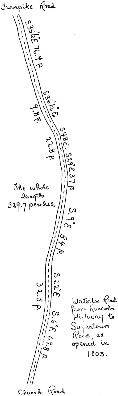
Turnpike Road, Church Road; Waterloo Road from Lincoln Highway to Sugartown Road, as opened in 1803 Edward Hugh was not buried in the old burial ground, forerunner of the beautiful cemetery at St. David's. He died (the gravestone says "entered") in December 1716, the year following erection of the Church, end lies close to the east wall of the church-yard. His is the earliest marked gravestone to be soon, a heavy marble stone laid flat the length of the grave in contrast to the simpler form of marker generally in use at the time. As in the case of the burial ground, the old road along the Welsh Line may be located today, but it is neither to be seen nor used. In Volume 22 of the Original Road Papers there appears in 1803 the petition of Lewis Morris, John Tucker, Samuel Fawkes, William Walley, Davis Res, Mordocai Davis, Samuel Bittle, William Williams, Benjamin Brown, Ann Templeton, Martin Bottorff (Potter), Jno. Reese, Whitehead Wetherby, F. Wayne, Philip Landis, James LOWE, Abel Reess, Griffith Wetherby, David Rees, Jr., Frederick London and Benjanmin Weatherby stating that the road is useless and burdensome and asking that it be vacated. There was no opposition, and on recommendation of the jury, Devault Beaver, Enoch Jones, John Brown, Thomas Walker, Stephen Stephens and Isaac Walker, vacation was decreed. At the sane time a petition was also filed setting forth the need for a road to head along a road laid out from tree to tree, courses and distances not being taken, and in use nearly 100 years. To begin at the turnpike road on the line of William Torbert and James Morris, which is the present beginning of Waterloo Road, and to end in the line of land of Azariah Lewis and John Smythe in a road leading from Paoli Tavern to Radnor Church, a distance of about a mile and a quarter. A plan of the road accompanies the petition, showing the road substantially as it is today. That is, coning to a dead end between Church Road and Newtown Road with a right-angle-turn each way to Sugartown Road which soon repeats such a turn to Church Road a chart distance to the east and Newtown Road a little way to the west. The reason for this awkward constructions seems apparent. It was the general practice of the earliest road builders to lay their road through the valleys rather than over steep hills. This was either for ease of travel or to accommodate the early settlers whose homes nearly always were near the springs and streams. Probably both reasons applied. The Jarman's Mill Road is thus to be found following the branch of Darby Creek. By 1767, however, other conditions prevailed and a shorter road over dry ground with but one bad hill was substituted. Shorter at least to the Square in Newtown, which was the main destination at that time. By 1803, however, the occupants of the half dozen or so houses along Darby Creek to Tarleton Court, all east of Waterloo Road, with other persons personally interested, must have decided that they preferred a township road on good ground nearer than the road along tho Welsh Line. Waterloo Road as we now know it to Sugartown Road was the result. The bad turns made little difference to the travel of the day. As it happened also, tho ancient graves in quiet sleep, again lay cradled in the arms of nature, freed at last from public desecration.
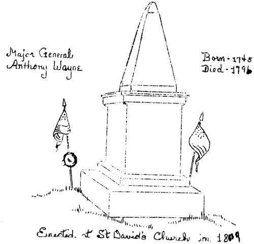
Cemetery memorial to Major General Anthony Wayne, born - 1745, died - 1796; erected at St. David's Church in 1809 |