|
Home : Quarterly Archives : Volume 7 |
|||||||||||||||||||||||||||||||||||||||||||||||||||||||||||||||||||||||||||||||||||||||||||||||||
Tredyffrin Easttown Historical Society |
|||||||||||||||||||||||||||||||||||||||||||||||||||||||||||||||||||||||||||||||||||||||||||||||||
|
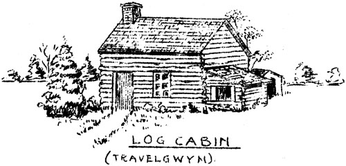
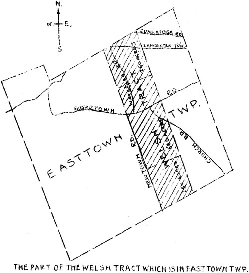
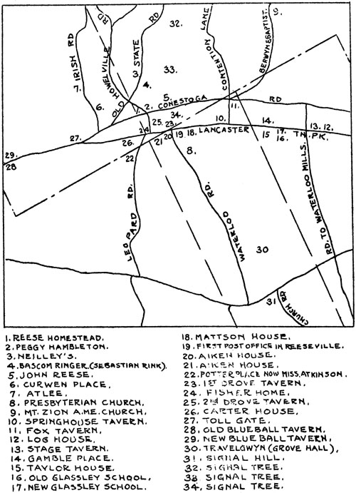
Source: July 1952 Volume 7 Number 3, Pages 47–59 The early history of Berwyn When in 1699 a deed was made to Howell James for one thousand acres of forest land in Easttown Township, extending from Tredyffrin to Newtown, a preliminary stop had been taken in the story of Berwyn, for James, a Welshman, was to be followed by others of his country - men and settlement began. To the west the boundary of the tract was the line of Newtown Road projected north by Walnut Avenue and known as the Welsh line. Eastward the line passed from the corner of Conestoga and Berwyn and Baptist Roads, by the spring north of Lancaster Turnpike, down the little valley of the branch of Darby Creek and through the western part of Devon to Newtown line. Two hundred and fifty acres along the north line of Easttown were conveyed to John Jones and then in succession to John Bentley, William Davis, John Hugh, Llewellyn David and Lewis Walker, a distinctly Welsh assemblage. In 1703 a tract of five hundred acres to the south was conveyed by Howell James to Edward Hugh, or Hughes, and south of this tract, reaching to Newtown Township, two hundred and fifty acres passed to John Jones, completing subdivision and transfer of the original tract conveyed to Howell James. Edward Hughes conveyed the northern one hundred acres of his property to his brother-in-law Philip Davis and the heirs of Margaret (Hugh) Davis, sister of Edward and wife of Philip. This ground was known as Travelgwyn.
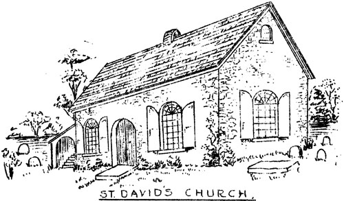
St. David's Church Thus the Welsh obtained, a part of Easttown, similar in proportion to other divisions made. Of especial importance was its general direction down the Darby Creek watershed, toward Welsh settlements in Radnor and Newtown. Unity among these neighboring Welshman was soon to appear in the establishment of the Episcopal Parish of St. David's Church, services having been held in the home of William Davis of Radnor, a close friend of Edward Hughes, as early as 1700. It is reported that a tradition existed to the effect that this Edward Hughes was the first rector of St. David's Church,but Mr. Pleasants, author of the church's history, doubted it. Services are said to have been conducted also near Signal Hill a short distance from which, west of Mr. Young's stable near the Welsh line, these Easttown settlers had established their burial ground. Whatever part Edward Hughes may have played, his importance in the founding and erection of the church was great. He died in 1716, the year after the church was built, and is buried in its cemetery beneath the oldest marked stone now to be seen. That the Welsh of Easttown wished to have the church built near their burial ground seems certain from the tradition that "the graveyard field" was strongly advocated as the site for its erection. Tradition has it that the present site was chosen because of good water facilities, but as there was a good spring and stream at the proposed Easttown graveyard site, it is probable that the advantage of having the church placed at the joint corners of Radnor, Newtown and Easttown Townships was the decisive factor in this question. The early records of St. David's are full of references to these early settlers of Easttown. They were in the foreground in the founding of the parish and the building and maintenance of the church. Apart from those commendable activities however, there is no indication that any of them carried on any trade or craft such as would have led to the inception of village life. They must have been engrossed with serious problems of the household and with the breaking and tilling of the soil after it was once cleared. Franklin Burns, who talked with Miss Ida May Davis and the Misses Sharp, members of the family so long owners and occupiers of Travelgwyn, published in his interesting paper on the property a reproduction from memory of the Travelgwyn log house near the spring, at the foot of Waters' Hill, a short distance east of Waterloo Road, and of the stone house a little further west. He gives the date of construction of the log house as 1706, of the stone house as between 1706 and 1725, and shows that in the latter year the house and ground were sold to Griffith Hughes, then rector of St. David's, and the name changed from Travelgwyn to Grove Hall. In 1710, upon a grand Jury's recommendation, a public road was ordered laid out from Jarmen's Mill on Valley Creek (later Great Valley Mill) to the great road to Philadelphia at old Radnor Hunt. It passed near the intersection of present Howellville and Conestoga Roads, along the Welsh line and between Edward Hughes' house and his barn. Access of a kind was thus afforded to Chester Valley where the farmer might procure line or have his corn ground, although for the latter purpose grist mills on Darby Creek would have been more convenient. Newtown Road was opened to present Sugartown Road in 1716, connecting the little settlement with the Old Square in Newtown Township. North of Travelgwyn the steep, rough and rocky ground had little appeal for the welsh settlers who obviously preferred the ground to the south. The entire two-hundred and fifty acre tract was sold in 1723 to Peter Elliott, a Radnor blacksmith, and a vestryman of St. David's. His name was applied to an ancient road leading to Conestoga Road, presumably from the probable site of his house and shop at the spring where Lincoln Highway and Lancaster Turnpike now meet. He conveyed a narrow strip of fifty acres along the east side of his purchase to his son Morris and left him his blacksmith tools by will. The remaining two hundred acres passed by sheriff's sale to John Llewellyn in 1759, after Elliott's death.
Log Cabin - Travelgwyn If along the north line of Easttown, conditions were not conducive to farming, they were infinitely worse along the south line of Tredyffrin. There are early deeds to Tredyffrin ground in the Welsh Tract but no special Welsh development along the township line seems to have occurred. Development here was to come from settlers of more modest means whose homes were located by the springs rising near the high ridge; also by the steady influx of settlers along Conestoga Road, which by 1720 had reached what is now Strafford as a Great Road of the province. Earlier as a usable trail, this road must have extended much further west for the pioneer and his pillion mounted wife with pack horse in the rear.
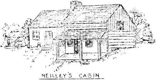
The part of the Welsh Tract which is in Eastown TWP. A typical early example of the houses of such a cross-roads settlement was Neilley's log house with its loom shed, north of the bend at the High School. Here cloth used to cover the faces of the soldiers killed in the night attack on Wayne's troops at Paoli, was supplied. The occupants are said to have heard the cannon at the Battle of the Brandywine. Another example was the grog shop sometimes ascribed to Peggy Hambleton, in the log house across Howellville Road from the old Reese home, then on its "Corner Lott" but now Mr Trowill's. The log houses on the Curwen and Atlee properties, the stone farmhouse of shoemaker Sebastian Rink, later the Burns' homestead on Orchard Way, and further east the John Reese (now the Wellers') log-and-stone house, east of the original log house near the well, are all standing, they are reminders among others, of the little backwoods settlement of Cockletown. In its day it did service to the local public and both the well-to-do and the riff-raff of the great stage and team road, the importance of which exceeded that of any highway of the day in opening the infant colony to the west. What matter if, when the road had acquired some degree of temporary smoothness, it occasionally did service as a track for the running horses of its time? Times were rough, taverns were convenient, and much liquor was consumed. Cockletown eventually fell in favor with straightlaced persons of the day, but it was a link with Travelgwyn, and between these points so different in origin and manners, Berwyn finally was to take strong root and grow.
Neilley's Cabin A road came south from the Conestoga to tap the little valley conveyed to Morris Elliott. Grubb's Hill Road, further east than the present Leopard Road, crossed Easttown from Crum Creek and, after bitter controversy in 1767, seemingly joined in by all the adults of the region, Jarmen's Mill Road of 1710 was vitalized and reopened over the Episcopal burial ground. Thus it passed along the Welsh line and continued with the Grubb Road to Conestoga and Howellville Roads at the present High School corner. The original Blue Ball Inn beside the spring by Conestoga Road - thens everal hundred feet south of the Highway at what is now Daylesford Station - opened in 1735 with Robert Richardson as landlord, to be succeeded in 1741 by Thomas McKean, an uncle of Governor McKean. Richard Iddings of Newtown, grandfather of Anthony Wayne had acquired a hundred acres in 1726 near the Conestoga and Howellville Road corner, and well before the Revolution the Llewellyn family had secured a large part of the two-hundred and fifty acre tract south of the Easttown line. A stone house west of the spring below the Doyle stable, Miss Atkinson's house on Leopard Road and, later, the old part of the William Coates house were to come. The Reeses and the Waynes were in force in Tredyffrin. Between the ancient settlements of Travelgwyn and Cockletown reduction of the forest barrier had begun. In the fall of 1777, following the Battle of the Brandywine, the British Army under Howe went into camp in the Great Valley, scarcely a mile from Cockletown. The quarters of its generals are known but the story is rather one of Chester Valley than of Berwyn. A few months later the Continental Army was in camp at Valley Forge and to guard against surprise attack and to cut off the supply of beef to the British Army in Philadelphia, a signaling system was put into operation from Signal Hill on Sugartown Road to Mount Joy. Tall trees were selected as observation posts and watchers posted in the tops. One of those trees, a chestnut, now lies in a fence row on the Ole Latch Farm south of the Trenton Cut-Off, another, on the Bodine property, north of Miss Bair's home, was felled in recent years, and a third stood at Cassatt Avenue between Conestoga Road and the railroad bridge. Roving bands of cavalry of the two armies scouted through the country, and at the Scott farmhouse, south of Tarleton oak at the then intersection of Church and Sugartown Roads, the picket post of Captain Harry Lee successfully held off a troop of British cavalry under Tarleton, who it is said, left a dozen dead behind; these were buried in the old Episcopal burial ground nearby. The region was in the path of the war, but few stories with special relation to the two settlements remain. Soon after the successful termination of the war and the adoption of the Constitution, a surge of development occurred in which the parts of Easttown and Tredyffrin along the Conestoga or Lancaster Road, as it was then called, had full share. In 1784 Henry Ruth of Easttown bought the fifty-acre Morris Elliott tract. Two years later he applied for a tavern license stating to the court that he was "daily troubled with a number of travelers calling at his pump for Water by Reason of a Scarcity of that article for a considerable distance". Thus was obtained a tavern license at the Fox, the old stone house which stood until about 1900 at the corner of Old Lancaster Road (its name in 1900) and Berwyn and Baptist Road. This farm house and the house which replaced it were long the home of the Williams family who conducted a store in the elder house. With the coming, in a few years; of the Philadelphia and Lancaster Turnpike, the tavern as well as the road itself were to decline in use. So much has been written by Mr. Sachse on the subject of the Turnpike that it may well be curtailed. It came through Berwyn between 1790 and 1800, of a width of fifty feet, and stone buildings mainly, few in number but of substantial type, were soon to appear along its course. Among them from the east, was the Spring House Tavern, near the presumed site of Peter Elliott's house and shop, and successor to The Fox. Part of this long low building still stands backed up against the railroad, and as a part of the Bronze Works plant. A casualty of the present day but reputedly a thing of beauty seventy years ago. The house was long the homestead of the Kugler family and after discontinuance of its tavern license, the well-kept residence of the Reverend John McLeod. The handsome Mattson house, on the opposite side of the pike and partly of logs, was further west. A frame house and store on the site of the present parking lot, adjoined it. West of Waterloo Road were the two stone Aiken houses, still safe behind their additions to the front. The owner, Thomas Aiken, was a weaver. The westernmost of the two houses did duty at one time as a cigar factory, managed in succession by members of the Neill and Gamble families. West of Leopard Road was the Potter farm with the old house and barn and, in the meadow toward the Highway, the old spring house beneath the great white oak. Each of these six properties still has the one thing needed to preserve the appearance of Berwyn as it was when known as Reeseville: Open ground on its Highway front. What an asset it would be from every point of view if these original house setbacks could be preserved and an appropriate stone wall run along the north side of the Highway. Instead of the present drab appearance of Berwyn's business front, the advantageous use and view of the two-and-one-half-century-old village would be one of permanent appreciation and benefit.
Springhouse Tavern In Tredyffrin, across the present upper bridge, there were the supposed two Drove Taverns. One, demolished in 1869, seems to have stood opposite the bridge and to have been kept in 1779 by Thomas Search; the other tavern is shown by Saschse, a pretty, hip-roofed house across Howellville Road from the Fisher home. The old Carter house stood across the turnpike from the Fisher house. Its owner had been assistant surgeon with Nelson at Trafalgar. Further west there was a toll gate, and directly up the hill from the first Blue Ball Inn is the second Blue Ball, long conducted by the late Prissy Robinson. About this time also came Glassley in the great Harrison tract east of the Welsh tract. It was promoted by Blair McClenachan who was connected by marriage with the Harrison family and with Charles Thomson of Harriton, Secretary of the First Congress. The map of Glassley shows it as extending from a little east of Warren Avenue to opposite Devon Station, and from the then Old Lancaster Road nearly to the present Lincoln Highway. Streets wore laid out and named but there were very few houses. To name several: The Gamble log house, now gone, east of Warren Avenue and on the north side of the turnpike; the Taylor log house, directly south, on the south side of the railroad, and the log house once the Devon Tea Room. An early road ran from Old Lancaster Road (so named on the map of Glassley) approximately on the line of present Fairfield Road, through what is now Devon to Waterloo Mills. This road was later to be closed and replaced by Waterloo Avenue at Devon Station. A school was erected on the property, as will appear. The Glassley project was a dismal failure and was to be labeled by Brooke, surveyor for the turnpike, as "Blasted Heath". The commons, as they were called, served one good purpose, that of occasional drill grounds for the militia. West of the log house at Devon, supposed to date from 1734, there was on the north side of the turnpike the stage Coach Tavern dating from 1810, later the home of Eber Beaumont and his son Theodore, after their removal from the farmhouse formerly on the north side of Conestoga Road. So far as known, the first school in Easttown was built on the ground donated by Robert and Amelia McClenachan about 1808. It was near a spring, west of Washington and south of Pearl Street, according to the old plan. Pupils in the first class are said by Mrs. Fisher to have been Robert Gamble, Ann Rowan whom he married, Samuel Epright, Hannah Neilley whom he married, Robert Neilley and Thomas Rowan. The old school house was finally abandoned, and in 1863 the school district built a new school, several hundred yards north of the old one and about a hundred feet back from the south side of the turnpike. It also was known as Glassley School. It was torn down about 1895, having been out of use for a number of years. In Tredyffrin there was a public school on the north side of the turnpike about a thousand feet east of Daylesford Station, just east of the lane from the Heyburn farm. The building was sold to Mr. Hatton who built his home on the grounds. From observation it may be said that this school was about as old as the second Glassley School. An early teacher in the first Glassley School was George Washington Lewis, who seems to have taught also at the Old Eagle School, and who was also Secretary of the Wilberforce Anti-Slavery Society. He was a carpenter and weaver and lived for many years in one of the several interesting old log houses down Contention Lane, a short distance south of the iron mine on the Latch Farm. This mine has long since been abandoned because of the expense of pumping out the water. The first meeting of the Anti-Slavery Society was held on January 23, 1837 in the first Glassley School. Reading of the minutes kept by Mr. Lewis, now in the possession of his grandson Brooke Longaker, shows the temper of the time to have been such that these meetings in public places were unwelcome. Members of the Great Valley Baptist Church were very active in the Society with their pastor, the Reverend Leonard Fletcher, at their head. Division arose in the congregation, however, and meetings were later held elsewhere than in the church. There are stories of the underground railway in the region of Berwyn, and Mr. Burns told one of children of the neighborhood, coming to breakfast in the early morning and unexpectedly coming in on runaway slaves. The old stone house near the creek at Newtown Road on the Humbert Powell property is said to have been a "station"; another is supposed to have been in Hammer Hollow. Unfortunately, but naturally, the Minutes are silent on such subjects. Just as the coming of the Philadelphia and Lancaster Turnpike was to dim the luster of Conestoga Road, so was the stagecoach travel and hauling of freight on the turnpike to be hard hit by the advent of the Philadelphia and Columbia Railroad. Within thirty odd years after the coming of the first great stone road of the day, coach travel, long-distance freighting, and the glory of the inns were beginning to depart. (In recent years motor-driven vehicles and tourist cabins have pushed the railroad hard to retain its one-time supremacy.) Reeseville, the first station at Berwyn, was a small boxlike affair east of the present station. The crossing for the old road from Fox Tavern and the turnpike, opposite the east end of the Bronze works, was at grade, as was the Grubb's Mill or Leopard Road crossing a hundred yards or so west of the present upper bridge. These two crossings remained in use up to about seventy-five years ago. There was then no bridge over the tracks at the station. The first church built in Reeseville was Trinity Presbyterian for which ground was broken September 28, 1861. Dedication followed on December 30, 1861 with the Reverend John McLeod, (donor of the ground in 1861) as the first minister. The building was replaced in 1891 by the present structure. Union services preceding formation of Church organization had been held as early as 1849 in the home of Dr. Reese opposite the Drove Tavern.
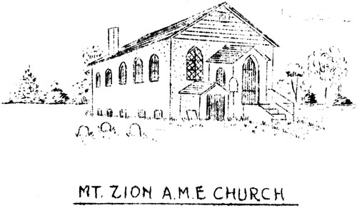
Trinity Presbyterian Church Mount Zion A. M. E. Church had its beginning about 1849 or 1850 in recognition of need for a church near New Centreville. Cottage Prayer meetings were held and organization was effected in the home of Henry and Sarah Roach of Hammer Hollow. Ground nearby was acquired in 1856 and building of the church begun in 1861 under pastorate of the Reverend Nelson Hughes and the Reverend Charles Beardley. Completion was delayed by the Civil War and followed under direction of the Reverend W.H. Davis. Substantial improvements were made to the original building a number of years ago. The first post office in Reeseville was opened November 12, 1881, in the old frame building at the southeast corner of Lancaster Turnpike and Waterloo Road, which was laid out in 1803, in substitution for the then vacated old road along the Welsh line. Milton Fussell, who lived in and conducted a store in the building, was the first postmaster, from him there has come down an interesting story of stirring times of another day. Following the Battle or Gettysburg, when the fate of the nation hung in the balance, a detachment of gray-clad troops came marching down the pike through Reeseville. In the crowd of watchers was a rebel sympathizer who, mistaking the soldiers for victorious Confederates, raised a cry of three cheers for Jeff Davis. Instant and vigorous response was a cold ducking in the horse trough. The dust-covered Union Soldiers had been dispatched from Philadelphia too late to join the battle and had been promptly headed off and marched back east. Following the Centennial Exposition in Philadelphia and in line with property development along its Main Line, the Pennsylvania Railroad inaugurated great improvements. The present station was built and the original name of Reeseville changed to Berwyn, a Welsh name probably drawn at random from among other Welsh names. The number of tracks was increased, and the grade lowered, and the wide, deep cut provided. The high bridge was thrown over the tracks at the station, Cassatt Avenue was opened and access was provided to the station from the north. It was at this time that the bridge over the tracks for the turnpike, at about the western Aiken house, was replaced by the upper bridge with the S-turn, and the grade crossing west of the bridge eliminated. The old stone Aiken houses were slid a considerable distance south to allow for the new width of the railroad cut, and expertly set on new foundations. Response of the village to the changes was prompt and vigorous. Houses and shops were erected on vacant ground and farm property north of Travelgwyn. Within a few years the village had become mainly a substantial and growing group of artisans' homes, the story of which is more applicable to the present era.
Mt. Zion A.M.E. Church This paper has been prepared from the records of the Club without opportunity for outside investigation. Foundation for the facts presented will be found mainly in the contributed articles of -
|
|||||||||||||||||||||||||||||||||||||||||||||||||||||||||||||||||||||||||||||||||||||||||||||||||