|
Home : Quarterly Archives : Volume 12 |
||||||||||||||||||||||||||||||||||||||||||||||||||||||||||||||||
Tredyffrin Easttown Historical Society |
||||||||||||||||||||||||||||||||||||||||||||||||||||||||||||||||
|
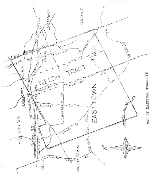
Source: October 1962 Volume 12 Number 2, Pages 29–36 History of Easttown Township On August 28th, 1609, Henry Hudson, the celebrated English Navigator in the service of the Dutch East India Co., described "a great bay" during a voyage which resulted in his discovery of the great river which bears his name. The Bay was entered the following year by Lord De La Warr and thus was established its name. The Dutch, having laid claim to this area, were interested in developing it for trade, and accordingly in 1614 the "Fortune", one of five vessels which were outfitted by the merchants of Amsterdam, arrived at the mouth of Delaware Bay. The commander of the "Fortune" was Captain Cornelis Jacobson Mey and he gave two of his names to the two capes at the entrance of the bay, Cape Mey and Cape Cornelis. We find the first definite effort at colonization made by the Swedes in 1633 under command of Peter Minuit. The Dutch and Swedes fought over this area until 1664 when the English entered the picture. At this time the Duke of York had dispatched an expedition to New Amsterdam which surrendered without firing a shot. Sir Robert Carr then went on to the Delaware River and subdued the fort there. In 1668 the government at New York was interested, not only in "settling of a garrison on the Delaware" but also in the "Importance of establishing courts of justice." By 1678 mention of the County of Upland describes it as "to begin from ye north syde of Oele Fransens Creeke otherways called Steen Kill, lying in the boght above ye verdrietige hoeck, and from the said Creek over to ye single tree point on the East syde of this river." "In other directions, Upland County extended as far as settlements had been made." (This would lead us to suppose that the present County of Chester and Township of Easttown were at one time part of the wilderness contained in Upland County). The courts had the power "to make fitting rates for the highways, poor, and other necessaries as is practiced in England." The justices of New Castle obtained authority from the Governor to levy a poll tax of 26 gilders upon each "tydable (taxable) person, which included every male inhabitant in the county between the ages of 16 and 60 years, except the justices, who were exempt from the payment of all taxes but those for the support of the church. This levy was to be collected by the high sheriff before the 25th of the following March, and instead of money he was authorized to receive "grains, tobacco, meat and wampum." While still in England after having secured title to the Province, Penn published an account of Pennsylvania for the information of those who might desire to emigrate thither, in which certain conditions are set forth: "first, to purchasers; second, to those taking up land upon rent; and, third, as to servants." Having disposed of a large amount of land by July 11, 1681, there were signed "certain conditions or concessions agreed upon by William Penn, Proprietary and Governor of the province of Pennsylvania and those who are the adventurers and purchasers in the same province." Among these twenty articles, No. 4 refers to the original plan set up for townships. "That where any number of purchasers more or less, whose number of acres amounts to 5 or 10 thousand acres, desire to sit together in a lot or township, they shall have their lot or township cast together, in such places as have convenient harbors or navigable rivers attending it, if such can be found; and in case one or more purchasers plant not according to agreement in this - concession, to the prejudice of others of the same township, upon complaint made thereof to the governor or his deputy, with assistance they may award (if they see cause) that the complaining purchaser may, paying the survey money, and purchase money, and interest thereof, be entitled, enrolled, and lawfully invested in the lands so not seated." TOWNSHIP SURVEYS. From the "Conditions and Concessions," before referred to, it appears to have been a part of the original plan to lay out the province in regular townships of five or ten thousand acres, and the clause "according to the method of townships appointed" was inserted in the warrants of survey. It must soon have been found impossible to preserve regularity, yet this clause was continued in the warrants until after the Revolution. In a letter to the Marquis of Halifax, dated 9th of 12th month, 1683, Penn says,"I suppose we may be 500 farmers strong. I settle them in villages, dividing 5000 acres among ten, fifteen or twenty families, as their ability is to plant it." In Bucks and what is now Montgomery County there was rather more regularity in the township lines than in Chester County. Concord township, as originally laid out in 1683, probably represented the proprietary's ideal in this matter, as it contained a street or road through the center from North to South, and the sub-divisions were all laid out with a proportionate width of front on the street, the whole comprising 6000 acres, but an addition has since been made to the south-west corner, destroying its rectangular form. The settlers were generally allowed to take up lands where they pleased, and the method of townships was soon lost sight of. There is now no township in Chester County which was laid out as such originally, though some of them, as Westtown and the two Pikelands, preserve the lines of early surveys. Marlborough was the only one within our present limits which appears to have been laid out according to method, but by the addition of adjoining land the original form is lost. Marlborough was laid out in 1700 and l701, and contained a street running east and west through the middle, while the line separating the lands of the different purchasers ran north and south from the street to the edge of-the township. A public road occupies the place of the street, and is well known as the Marlborough Street. Other large tracts were laid out for individuals and companies and eventually became townships, as was the case with New Garden, London Grove, Newlin, Pikeland, and Vincent. The formation of townships and counties proceeded, in general, in a somewhat similar manner. As the settlements extended, and the inhabitants became sufficiently numerous for purposes of civil organization, new townships were established. The boundaries, however, often remained indefinite for a long time, until the inhabitants would petition the court, setting forth that they "labored under great disadvantages thereby, and praying that the lines might be settled." On the 28th of October, 1682, Penn landed at Upland. Without reflection, Penn determined that the name of this place should be changed. Turning around to his friend Pearson, one of his own Society who had accompanied him in the ship "Welcome", he said "Providence has brought us here safe. Thou hast been the companion of my perils. What wilt thou that I should call this place?" Pearson said "Chester" in remembrance of the city from whence he came. Penn replied that it should be called Chester, and that when he divided the land into counties, one of them should be called by the same name. When Penn returned on November 25, 1682, from a visit to New York he caused three counties to be laid out - Chester, Philadelphia and Bucks. Within a year the outlines of the "Welsh Tract" were run according to the following agreement, written by Penn: "Whereas divers considerable persons among ye Welsh Friends have requested me yt [sic] all ye Lands Purchased of me by those of North Wales and South Wales, together with ye adjacent counties to ym, as Haverfordshire, Shropshire and Cheshire, about 40,000 acres, may be layd out contiguously as one Barony, alledging yt ye number already come and suddenly to come, are such as will be capable of planting ye same much within ye proportion allowed by ye custom of ye country, and so not lye in large and useless vacancies. And because I am inclined and determined to agree and favour ym wth any reasonable Conveniency and priveledge: I do hereby charge thee and strictly require thee to lay out ye sd tract of Land in as uniform a manner, as conveniently may be, upon ye West side of Skoolkill river, running three miles up on ye same, and two miles backward, and then extend ye parallel with ye river six miles and to run westwardly so far as till ye sd quantity of land be Compleately surveyed unto ym,--Given at Pennsbury, ye 13th 1st mo. 1684." Wm. Penn The following mandate issued July 25th 1687, gives the limits of the Welsh Tract:--"Beginning att the Schoolkill, thence running W.S.W. by the City liberties 2256 perches to Darby Creek. Thence following up the several courses thereof to New Towne Line, Thence up the said line N.N.W. 448 perches, Thence S.S.W and by New Towne, 988 perches, to a corner post by Crum Creek, Thence down the several courses thereof 460 perches, Thence W. and by S. by a line of trees 1920 perches, Thence N.N.W.;, by a line of trees – Thence E. and by N. by a line of trees, 3040 perches, Thence E. and by S. 1120 perches, Thence S.S.E. 256 perches, Thence E.N.E. 64O perches, Thence S.S.E; 1204 perches, Thence E.N.E. 668 perches to the Schoolkill, Thence down the several courses thereof to the place of beginning." In 1684 the following order issued by the surveyor general includes the first definite mention of planning the townships: "To survey and sett out unto the said purchasers the said quantity of land, there, in manner as before ex - pressed, and in method of townships lately appointed by the Governor att five thousand acres for a township and to be directed 'for placing the villages of each Township and division of the purchasers' by Thomas Lloyd, Master of the Rolls, who is principally concerned therein." The large survey included the townships of Haverford, Radnor, Merion, Tredyffrin, Whiteland, Willistown, Easttown, Goshen, and part of Westtown. In the Tredyffrin-Easttown History Club Quarterly, Vol. 7, No. 3, published July 1952, there is a reference to the Welsh Tract comprising 1000 acres which extended through Easttown Township. (See map on P. 50 of that issue.)
Map of Easttown township In spite of the fact that Easttown was one of the townships named there is no mention of it in a list of taxable persons for 1693. At that time there were 276 taxables in the County of Chester. Easttown Township was no doubt named because it was east of Chester which was the principal settlement at that time. When looking through various court records for facts relative to Easttown Township the following spellings were found for its name: Easton, Eston, Estown, Eastown, Eastoun, Eas Town, Est.town, and East Town. Since the land contained in Easttown Township was included in the "Welsh Tract" there is reason to believe that there may have been some settlers before 1704, which is the date given for the "erection" of the township. We know that groups of settlers had the right to petition the courts for a survey so that the lines could be drawn and a township could be set up. It is quite possible that this was the case in Easttown. On an old survey map of Easttown Township one finds that there were three divisions of acreage which together total about the amount necessary for a township as designated by Penn, 5000 acres. The one purchase made in England 1681 by James Claypoole covered 1050 acres; the other purchase was made in 1684 by William Wood and William Sharlow of two parcels of land, one for 1050 acres and another for 1380 acres. At the conclusion of "An account of the purchase Concurred in the Welsh Tract. Granted by the General Wart by which the said Tract was Laid out and such Lands as hath bine Laid out Warts Dulie Executed within the same, and 1st of ye Ould England Purchesers" is the following: "Besid William Wood and Sharlo, and Thomas Barker and Jobsons 1000 acres allowed off to be within the said (Welsh) Tract." Records containing mention of Easttown Township show that there were settlers actively setting up their lands by about 1700. For instance - "John Jones by his Attorney William Davis delivered a deed to John Buntly for 250 acres of land in Eston dated the 19th of Oct. 1701." Other references follow:- "Howill James by his Attorney David LLoyd delivered a deed to Edward Hugs for 500 acres of land in Easttown dated the 19th of November 1703. Edward Hugs obliges himself in open court to pay all the arrears of the levys due upon the above 500 acres of land." "John Bartly by his attorney Hugh Williams delivered a deed to Wm. Davis for 250 acres of land in Easton dated the 18th 12mo. 1703. "John Jones by his attorney William Davis delivered a deed to John Buntly for 250 acres of land in Estoun dated the 19th of October 1701." William Thomas was appointed Constable of the Township on December 27, 1704, and the following court record gives him the order to collect taxes: "The Justices and Grand Jury appoints the Constables of East township to collect the 3 pence per 73 pound 12 shillings per head as laid the last Court. According to the duplicate that are now made for the Gov'r. tax and according to the same rate and by the same Authority the Constables shall have power if any Township or any of the persons thereof think themselves aggrieved by the unequality of the rate that then if they will undertake to pay the sum total to the said constable within the time limit they are hereby empowered to assess themselves as they please or think fit and one half or moiety to be paid at on or before the 10th day of the 4th month next to the Treasurer or Supervisors as by their warrants directed and the other half to be paid the eighth next." Later there is mention of "William Thomas", Constable of Eston, making default, are severally fined in the respective sums of ten shillings for their default and the same to be forthwith estrated. In the assessment of 1715 we thus find the Easttown Rate:
Concerning the boundaries of Easttown Township we find that it has always been surrounded by the following townships: Tredyffrin across the top and half-way down the right side, with Radnor Township line extending the rest of that side, Newtown across the bottom, and Willistown extending along the left side. In 1739, upon the erection of Delaware County, Radnor and Newtown Townships were included in that county. From the Pennsylvania Archives, Vol. #1 of the third series, there is a case listed in which one John Hort, purchaser of 1000 acres in 1685, had his land surveyed, and later, after his death his widow tried to sell the land, it was discovered that others had been granted rights to part of the same land. "And that the People settled on the Lands will not let him (the surveyor general) have their papers to satisfy the proprietary Agents of this fact. But some of them have shown their papers to one Mr. Wm. Wayne who informs him that the Lands they hold are upon other rights than Horts." The Board overruled this however and felt that the land was Hort's but held that the Warrant ought not to be granted until the whole matter was cleared up. Since John Hort owned the land in Tredyffrin Township at the extreme left corner above Easttown, this may be the explanation of the small jut of land or chimney at the one corner of Easttown Township. The whole case will bear more study. TopReferences in this article are made from the following authorities: Pennsylvania Archives, Series 1, 1664-1747: Series 111, Vol.1 Futhey and Cope, "History of Chester County". T-E History Club Quarterly, Vol.1 #2; Vol.2 #l;Vol.7 #3. C. W. Heathcote,Sr. "History of Chester County" Chester County Historical Society Excerpts from court records of Chester County Maps of Easttown Township |
||||||||||||||||||||||||||||||||||||||||||||||||||||||||||||||||