|
Home : Quarterly Archives : Volume 42 |
|||||||||||||||||||||||||||||||||
Tredyffrin Easttown Historical Society |
|||||||||||||||||||||||||||||||||
|
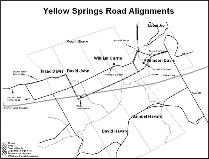
Source: Fall 2005 Volume 42 Number 4, Pages 107–109 YELLOW SPRINGS ROAD A HISTORY Hint for using the footnote reference links: Using the “Back” feature of your browser will return to the previous [Note] link location after you read the footnote. The Delete (Mac OS) or Back Space (Windows) keys often perform this function. The eastern part of Yellow Springs Road was set out in 1768. This road took a different route from the present one. This article discusses the different routes the road has taken over the years. In the 18th century roads were created through petitions to the county court. In this case the petitioners were: Joseph Mitchel, William Currie, Thomas Hockley, Samuel Havard, Sampson Davis, Thomas Potts, and David John. The petition is shown in Appendix A. The road is described as going between the road that leads from John Rowland's Mill—Great Valley Mill—to Yellow Springs, and the road that leads from Radnor Church to the Fatlands. The first road mentioned is now North Valley Road and then the western end of Yellow Springs Road. The second road was called Baptist Road, as it passed next to Great Valley Baptist Church. It now is Valley Forge Road, part of Route 252, and the trace road that runs across Valley Forge National Historical Park to the Schuylkill River. Yellow Springs is the health resort near Chester Springs that takes its name from the iron in the water and is about 9 or 10 miles west of this area. A license to operate an inn there had been granted in 1750. [Note 1] It was probably the nearest community going westward at the time the road was laid out. All the petitioners, except Thomas Hockley, who was the manager of the Mount Joy Forge, owned land on the line of the road—presuming Thomas Potts had inherited the land of the late John Potts. The Potts family, who ran the forge at the time, owned land along the North Valley Hills, and the road would have provided better access to that land. The petition was reviewed by the court—shown in Appendix B—and a group of viewers was appointed. These viewers were responsible for walking the proposed road and suggesting a route. The court then reviewed the viewer's report— shown in Appendix C—and approved the laying out of the road. It is not clear how much effort was expended to “build” the road. Ongoing maintenance had become the responsibility of the township. Specifically, the Supervisor of Roads—an annual position held in rotation by men of the township who were landowners—was responsible for ensuring the roads were maintained. The description of part of the alignment is given in Appendix A and is shown below.
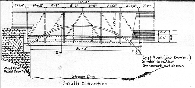
The road had a more southerly alignment than at present as shown by the inclusion of the Havards. As often was the case, the road ran along the property boundaries. The remains of this road can be seen in the woods in Valley Forge Park. An alignment for the road in the Park at the time of the encampment is given in Rhodes et al. [Note 2] It suggests that the road went to the west side of Knox's Quarters. It is more likely to have been on the east side as the slope of the land is much less on this side of the house. Later a road was laid out from where Valley Creek goes between Mount Joy and Mount Misery southwards to the Wilson farm. This was known as Wilson's Road. Initially, the crossing of Valley Creek was by ford. The first bridge was built over the creek in 1851. Frederick Wood won the contract to build the bridge with a bid of $814. It is not clear that the first bridge was covered. A 1842 plan for the bridge is shown below and this can be compared with a plan for the present bridge also shown below.
1842 plan for the bridge over Valley Creek.
Plan for the present bridge. All illustrations courtesy of the author. A flood destroyed the first bridge in July 1865. Robert Russell rebuilt it at a cost of $1179. Witmer's Atlas of 1873 [Note 3] shows the road going west from the covered bridge down Wilson's Road, then turning a right angle to go directly west to the Walker School, [Note 4] then north to join the present alignment of the road. The present day alignment is shown as a farm track on the map. Breou's Atlas of 1883 [Note 5] shows the road with its present alignment. The covered bridge is also known as the Knox bridge. It is not clear whether this refers to General Henry Knox who stayed nearby during the encampment, or Senator Philander Knox who owned the adjacent farm in the early 20th century. The bridge has had to be repaired on several occasions. In 1958 it was damaged by arson and was rebuilt. Then in 1967 a truck drove through the side of the bridge. The bridge has been the subject of many paintings and drawings over the years. [Note 6] [The documents in these appendices can be found in Road Docket R, page 28, Chester County Archives.] Appendix A To The Honorable The Justices of the Court of Quarter sessions To be held at Chester The Last Tuesday In May 1768 The Petition of us The Subscribers Humbly Sheweth That wheras Several of the Inhabitants adjoining our Settlements have Enclosed Their Plantations by Reason of which we find It Difficult to Carry on Business To our own advantage or the Emoluments of the Public Therefore We Humbly pray That your Honours would be pleased to appoint a jury To View & Lay out a Road From The Road which Leads from John Rowlands mill to The Yellow Springs Into the Road which Leads from Radnor Church To The fatt Land By our Settlements and Your Petitioners Shall as In Duty Bound Ever pray
We whose names are hereto Subscribed are of oppinion That There is a necessity for a Road; In The place petitioned for as above which nevertheless we Submit to The Judment of the Court
Appendix B Chester County Ss. At a Court of general Quarter Sessions held at Chester the thirty first day of May 1768 Before Wm. Moore, Esqr. And his Companions Justices present Its ordered that Randle Malin, Joshua Evans, Thomas McKean, Thomas Waters, James Davis Jr, Anthony Wayne Do view & if they see occasion layout a Road from the Road which leads from John Rowlands Mill to the yellow Springs into the Road which leads from Radnor Church to the Fatt Land With the least damage & Inconveniency of the Neighbours & Parties concern'd & least injurious to the Settlements thereabouts & make return of the Courses and Distances thereof and their Proceedings therein to next Court of general quarter Sessions to be held at Chester with this Order and whether the same be for public or only private Use.
Appendix C Whereas by an Order of May term last past We the Under Named Subscribers were Directed, to View, and if we seen Occasion lay out a Road from the Road which leads from John Rowlands Mill to the Yellow Springs Etc. Pursuant thereunto we meet the 13th day of August anno Dom 1768 and Proceeded as Followeth Viz Beginning in the Road which leads from John Rowland's Mill to the Yellow Springs, thence N48°E through part of the land of John Maxwell 16 perches to a Spanish Oak tree on Adam Rickbeaumer's land, thence N72½°E 59½ perches to a White Oak grubb on sd Rickbeaumer's land, thence N46°E 124 perches through the sd Rickbeaumer's and John Rowland's land to an old stump on the land of Rev John Simingtown thence N80°E 20 perches to a little Black oak tree on the Land of the widow Crisby, thence S80°E 27 perches to a White oak grubb, thence N64°E 46 perches to a Black Oak tree, thence S54°E 62 perches to a new Road on the line of the sd. Crisby and Joseph Mitchell's Land, thence N85°E 60 perches to a Black oak tree on the land of the sd. Mitchell and land of the late John Potts, 134 perches to a Black Oak tree, being a corner of the Lands of Isaac Davis esq. and David John thence S24°E along the line of sd. Davis, and John 188 perches to a Black Oak tree, thence S36¼°E 13¾ perches to a post in the line of the land of said David John & David Havard, thence N76¼°E and along sd. Line 216¼ perches to a post, thence S80¼°E 11¼ perches to a post in the line of the land of Samuel Havard thence N44½°E 13¼ perches to a little Walnutt tree in the Line of the land of sd. Havard & the Rev. William Currie, thence N67¼°E along said line 50 perches to a Hicory tree being the Reputed Corner of the Lands of sd. Havard & Currie, thence N55°E 35 perches to a White Oak tree, thence N49°E 23 perches to a White oak, thence N60½°E across Valley Creek to a post 9 perches, thence N51°W 13 perches to a post, thence N36¼°E 16¼ perches to a post, thence N73°E 86 perches to a little White oak, Standing in the saide of the Road, which leads from Radnor Church to the Fatlands, all of which last Mentioned Courses and Distances through the Land of Samson Davis Which we Return as a Publick Road, and Submit to your Worships for a Confirmation.
Viewers Return REFERENCES
Mike is a frequent writer about Valley Forge Park history. |
|||||||||||||||||||||||||||||||||