|
Home : Quarterly Archives : Volume 43 |
Tredyffrin Easttown Historical Society |
|
Source: Winter 2006 Volume 43 Number 1, Page 40 Then... & Now 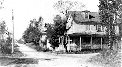
Above: Lucy Sampson photograph c. 1908. 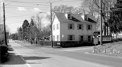
There are surprisingly few differences between these two pictures taken at a major Berwyn intersection approximately 100 years apart. The top photograph, dated c.1908, shows the intersection of Howellville Road and the Lancaster Turnpike—also known as the Lincoln Highway at the time this photograph was taken. The dips in both roads still stretch off into the distance, although the dirt road of the Turnpike is now paved. A similar shadow over the road on the left is seen in both images. The house has lost its porch and two close trees, and has gained a hedge and shutters on all the windows. Some of the shed-like structures behind the house in the older image have been removed to provide parking space for the contemporary building now housing the offices of Peter Zimmerman Architects. The building is now completely surrounded by the Tredyffrin/Easttown Middle School. According to a 1726 deed, Richard Iddings, grandfather of General Anthony Wayne, purchased a 100-acre property on the northwest corner of this intersection at a sheriff's sale. When this property was listed for sale in 1744 in the Pennsylvania Gazette it was described as a plantation with a house. Mildred Bradley Fisher, co-founder of the Tredyffrin Easttown History Club, lived in this house. When club member Herb Fry was going through some papers found at the house at a later date, he discovered the drawing below. 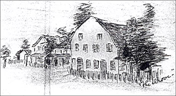
The Ruffenach Funeral Home now sits on the northeast corner of this intersection. Back in the 1800s, this was the site of the [second] Drove tavern, the lowest category of inns and taverns—after the inns for stagecoaches and the taverns for wagoners. These were drove stands catering to the rough drovers who drove herds and flocks of animals along roads, including the Lancaster Turnpike, from place to place. Like many of the drove stands, this Drove had a reputation as an unsavory place. The drawing at the right was made by Mary Okie Croasdale around 1937. The fence on the northeast corner in both the older photograph above and the drawing can be seen, as well as the porch on the house on the other side of Howellville Road. The size of the tavern is considerably larger than the house and it dominates the intersection. |