|
Home : Quarterly Archives : Volume 43 |
Tredyffrin Easttown Historical Society |
|
Source: Fall 2006 Volume 43 Number 4, Pages 119–126 SCENES ALONG THE CHESTER VALLEY RAILROAD Hint for using the footnote reference links: Using the “Back” feature of your browser will return to the previous [Note] link location after you read the footnote. The Delete (Mac OS) or Back Space (Windows) keys often perform this function. This is a shortened version of a longer presentation on the Reading Railroad's Chester Valley Railroad (ChVRR) and shows scenes in Tredyffrin Township. The primary purpose is to record these now mostly vanished railroad scenes in our nearby countryside. The Reading Railroad's Chester Valley Railroad (ChVRR) branch operated over its 21-mile length from Bridgeport to Downingtown from 1853 until early in the 1980s in the Conrail era. Previous articles in this Quarterly have described the corporate history, construction, and some details of local operation. [Note 1] [Note 2] [Note 3]
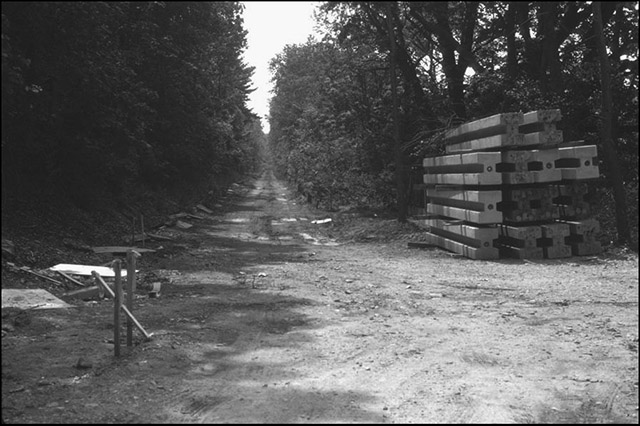
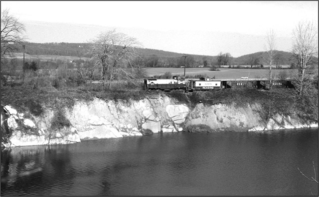
Figure 1. View west along the former ChVRR roadbed at New Centerville. The first view [Figure 1] looks westward along the cleared former right–of-way (ROW) from a point about 200 yards west of West Valley Road. This location was known as “New Centerville” on the Reading's timetables and also on township and U.S. Geological Survey maps. On 28 November 1910 the name of the Philadelphia and Reading Railroad station there was changed to “New Centerville” from “Centreville.”4 We see the early stages of erection of concrete sound barriers along the reconstructed Route 202 corridor. The single track had been removed in the mid-1980s but most of the ROW from Downingtown to Bridgeport was by then earmarked for conservation as the “Chester Valley Trail” [Figure 2].
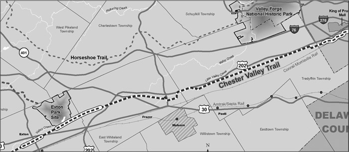
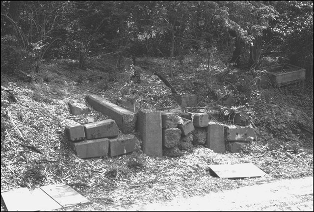
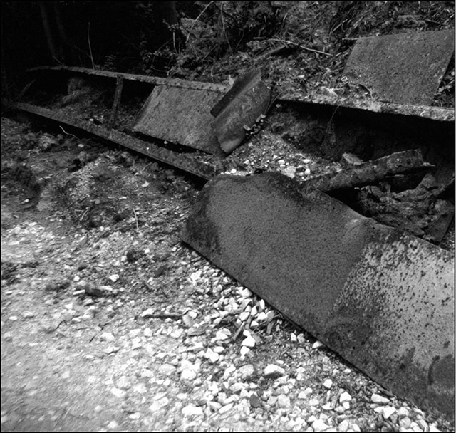
Figure 2. The broken line running from the upper right corner to the bottom left corner shows the section of the proposed Chester Valley Trail that follows the track bed of the former Chester Valley Railroad through the areas covered in this article. The filled in portions on the section reproduced here of the entire map are the completed parts of the trail as of September 22, 2005, the date this map was prepared by the Chester County Department of Parks and Recreation. Courtesy of Chester County Department of Parks and Recreation. On an earlier tramp in May 2000 along the ChVRR ROW at this same location, I noticed a familiar and older design of concrete piles, neatly stacked along the south side of the shallow cut [Figure 3]. The trapezoidal shape looked remarkably like that of the supporting pillars of railroad water tanks I had seen in model railroad layouts, although nothing like the “modern” steel water tank I had seen in the 1940s on the Reading mainline near the ChVRR terminus in Bridgeport. Furthermore, there was a concrete cistern inlet just westward on the bank behind the stack and also visible in Figure 3. Further examination that day revealed a fabricated sheet iron trough that had recently been dug up in the preparations for the sound barriers [Figure 4]. Could there have been a steam locomotive water tank at Centreville or even later at New Centerville? I communicated this query to a small network of local and railroad history buffs and received in response a series of three successively more illuminating insights.
Figure 3. Concrete piles, now dismantled and stacked, which once supported the ChVRR water tank at New Centerville. Note the concrete cistern inlet near the middle right edge. Photograph by the author, May 2000.
Figure 4. Closeup of the iron ChVRR water trough near the former New Centerville
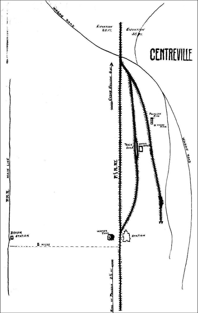
station. The first of these responses was a map sketch [Figure 5] (see the next page) provided by Richard Bates. [Note 4] The date of this map's preparation is approximately 1899. It depicts the track layout at Centreville and was prepared as part of a file on the building of three coal bins. First, there is a station and a water tank, just west of the [West Valley] road to “DEVON STATION [on the] P.R.R. MAIN LINE”, “two miles” south. There also are two side tracks on the north side. [On this map north is to the right and west is at the top.] The closest, a through track, is indicated as having a “track scale” and a “small office” to weigh cars. The Philadelphia and Reading records at the Hagley Museum and Library show that this was constructed in 1875. This was most likely in response to the development of the limestone quarries in Tredyffrin just west of Centreville in Howellville and vicinity. The “Proposed Bins” are on the northernmost dead end track, near the “wagon road”—today's Swedesford Road / Route 202 combination. Note that the alignment of Old State Road crossing the ChVRR and the fork road indicated going to the northwest are so drastically different from even mid-twentieth century memory.
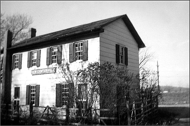
Figure 5. Philadelphia and Reading Railroad sketch of the ChVRR line outlining the trackage at Centreville, Tredyffrin Township, ca. 1899. The sketch shows the water tank, track scale, and station, and was part of a file relating to the building of three coal bins. The orientation of this map is that north is to the right and west is at the top. Courtesy of the Hagley Museum and Library. The record at the Hagley indicates that by 1953, the first year of the Reading's complete dieselization, the water tank at New Centerville had been dismantled. [Note 4] The second response to my query came from Tredyffrin Easttown Historical Society member Mike Bertram. The 1899 map shows the New Centerville station on the north side of the track, opposite the water tank. The view in the photograph in Figure 6 would have been from the track or south side of the former station which by then was being used as a private residence. Route 202, then a two lane concrete road, is in the near background.
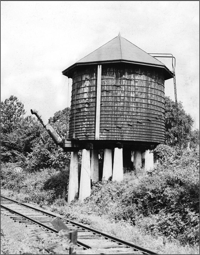
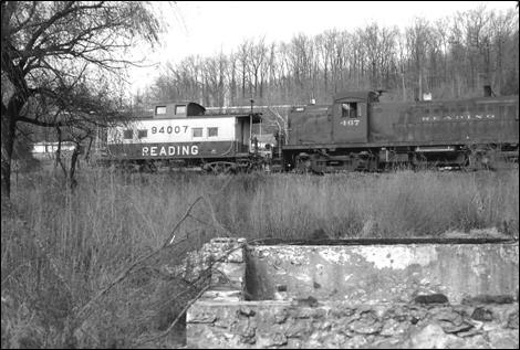
Figure 6. The former ChVRR station in New Centerville. Photographer unknown, c. 1960. The third response came as a result of a remark to Al Giannantonio, president of the Philadelphia Chapter of the Pennsylvania Railroad Technical and Historical Society at that organization's August 2006 meeting that there did not seem to be any original or useful copies of photos extant of steam locomotive operation on the Chester Valley. Al replied that he had some photos in his collection [Note 5] he would be willing to supply for my presentation. Among these photos was the water tank which was labeled “Water Tower and Plug at New Centerville, Tredyffrin Township” [Figure 7]. Note the configuration of the concrete pier supports. Also note the elliptical shape Reading Railroad “W” whistle sign beyond the tank on the right side of the track. A “W” sign usually indicated the proximity of a grade crossing.
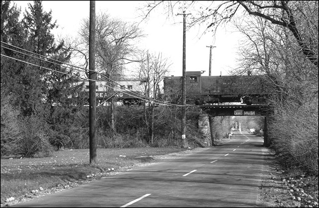
Figure 7. The water tower and plug at New Centerville, Tredyffrin Township. The next scene along the Chester Valley is of the “Valley freight” [Figure 8]. This was the local freight that ran out the length of the branch from Bridgeport, as distinguished from the “stone train” which ran for about two miles from Bridgeport out to the Bethlehem Steel limestone quarry in Upper Merion. The then quite modern General Motors Electromotive SW1500 diesel-electric switch engine is westbound, crossing the girder bridge over Devon-Valley Forge Road. Note the newly completed Route 202 overpass in the background and the lettering on the white wall of “Miss Jeanne's Crossroads Tavern” behind it. Today this tavern is the Winberie Restaurant and Bar. The girder bridge and its stone abutments were removed around 1995.
Figure 8. Reading diesel switcher hauls freight west across Valley Forge Road,
Tredyffrin Township. The next view [Figure 9] is a mile or so farther west and was taken from Route 252 in February 1971. The Valley freight is westbound, passing the abandoned and water-filled Johnson's quarry. The Reading hopper cars are likely destined for a customer west of Tredyffrin. Note the new Route 202 in the background and the open farm land which would become the Chesterbrook development. Mount Joy in Valley Forge is prominent on the right side of the photo.
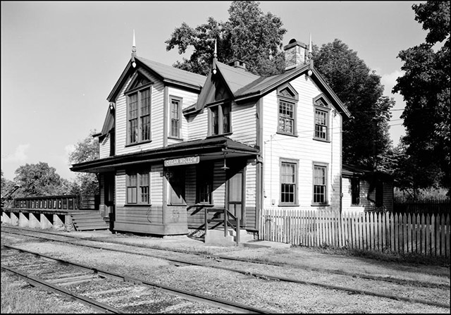
Figure 9. Hauling hoppers west past Johnson's quarry, Howellville as photographed from Route 252. Note the newly constructed Route 202 beyond the train. Photograph by the author, February 1971. Traveling about another mile farther west along the ChVRR, we see a view of the Cedar Hollow station [Note 6] [Figure 10]. This combined passenger and freight station and agent's residence was built by the Philadelphia and Reading Railroad in 1872. In 1918 George M. Ford Sr., a young Philadelphia and Reading “front agent” at its Chester Springs, PA station, was promoted to stationmaster at the Cedar Hollow station on its Chester Valley line and moved into the old station/house with his wife and children. George Sr. served not only as the Reading stationmaster, but also as the Western Union telegrapher, the Railway Express agent, and as the postmaster for the Tredyffrin Post Office there at the station until 1930. The Fords raised a large family in the house and Mr. Ford continued as freight station manager until 1948 when he died while on duty as stationmaster. The Reading kindly allowed Mrs. Ford to continue living in the residence where she resided until her death in 1952. The Cedar Hollow station remained unoccupied thereafter until its destruction by arson on August 24, 1964.
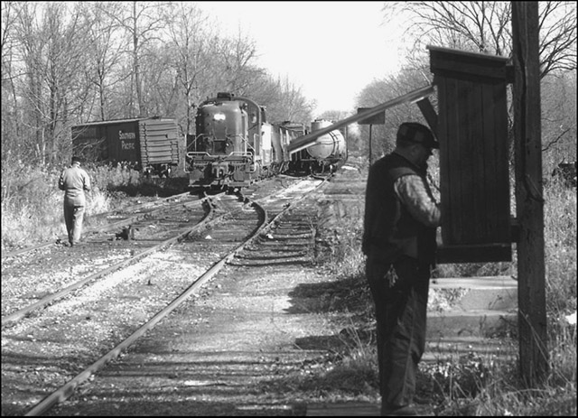
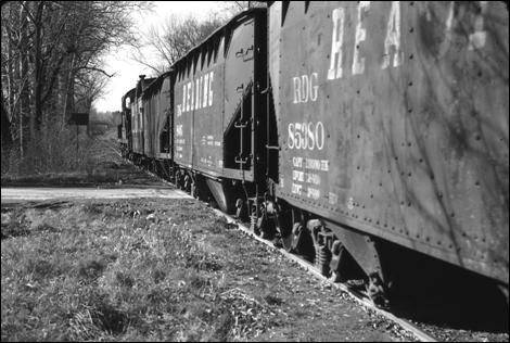
Figure 10. The ChVRR Cedar Hollow Station. Photograph by Ned Goode, August 1958. Library of Congress, Prints and Photographs Division, Historic American Buildings Survey, Historic American Engineering Record, HABS PA.15-PAOL.V.4-1. On a sunny day in December 1967, I took a series of slides of the Valley freight operations at Cedar Hollow, including the spur off the Chester Valley branch to the Warner quarry. We see a train [Figure 11] of mixed hoppers, box, and tank cars with the usual 1950s–1960s Reading Company Alco RS-3 road–switcher diesel locomotive in dark brown paint and a caboose in the yellow and green paint scheme of the 1960s. These trains operated daily except Sunday and in the 1960s regularly departed Bridgeport westbound in the late AM with 20-30 cars. A Southern Pacific boxcar is on the spur track to the left. The freight conductor is calling from the railroad phone box for updates on the train's work assignments along the branch and is also probably getting approval to enter the Warner quarry property at Cedar Hollow / Devault. The station remains are behind and to the right of the phone box. Note, for example, the concrete steps.
Figure 11. Conductor uses the telephone box near Cedar Hollow Road. Note the
boxcar. Looking east the same locomotive (#467) is seen [Figure 12] pushing the caboose and crossing over Swedesford Road northbound on the Warner quarry spur. We are looking eastward on Swedesford Road. Great Valley Presbyterian Church is visible through the overpass opening. Since the engine and caboose are without cars, we can assume they are going to the quarry to pick up loads. In the next photo [Figure 13] the same engine and caboose are just approaching the grade crossing at Church Road before entering the Warner quarry property. This photo was taken near the intersection of Church and St. John's Roads. Note the white railing on the Pennsylvania Turnpike on the North Valley hill behind the train.
Figure 12. Looking east, the same locomotive and caboose cross over Swedesford Road in Tredyffrin Township on the Warner Company spur. The Great Valley Presbyterian Church can be seen in the distance through the overpass. Photograph by the author, December 1967.
Figure 13. Looking north, a Reading locomotive and caboose approach the Church Road crossing in Tredyffrin Township, leaving the Warner Company Cedar Hollow quarry. Photograph by the author, December 1967. In the next photo [Figure 14] a similar consist Valley freight is seen crossing over Cedar Hollow Road westbound after working the Cedar Hollow spur. The property immediately ahead of the train is now The Vanguard Group complex. Note the overhead road bridge in the distance. The enlarged view [Figure 15] may be the last surviving photograph of the Matthews Road Bridge.
Above: Figure 14. Reading hoppers cross Cedar Hollow Road heading west.
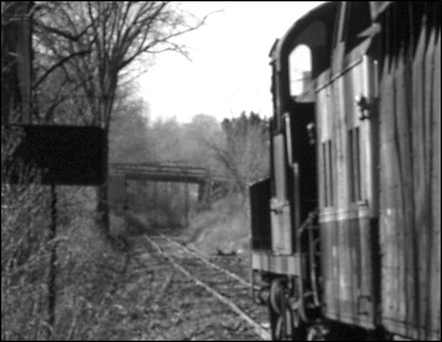
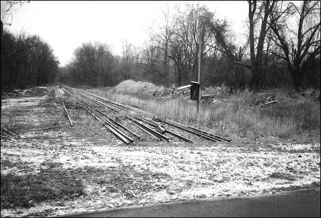
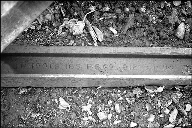
On February 26, 1995 I stood on Cedar Hollow Road and looked east along the railroad [Figure 16]. The tracks were still in place east of Cedar Hollow Road but had been removed from the road grade crossing and the Vanguard property to the west. The railroad telephone box was still in place with the door lid open. The next photograph [Figure 17] is a close-up view of the embossing on one of the “OH [open hearth steel rail] 100 LB. [to the yard rails produced by] P.S.Co. 1912.” They had seen seventy years of use.
Figure 16. Looking east from Cedar Hollow Road along the former ChVRR right-of-way. Debris from the station and even the phone box are still seen. Photograph by the author, February 1995.
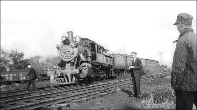
Figure 17. Amidst the destruction of the roadbed, a ChVRR rail from 1912. Last is a black and white photograph [Figure 18] taken at Downingtown in 1938 on a “fan trip” which was part of a National Railway Historical Society National Convention. The chartered Reading excursion train had traveled via the Chester Valley Railroad to the Pennsylvania Railroad connection at Downingtown through the Tredyffrin scenes shown in this paper. The coal-burning steam locomotive, #556, is a 4-6-0 wheel arrangement “camelback,” Reading class L3e, originally constructed in 1898 by Baldwin Locomotive Co. in Philadelphia, but much modified and life-extended through the years by that thrifty railroad. [Note 7] The train makeup is two passenger coaches followed by an open gondola full of railfans.
Figure 18. ChVRR “fan trip” in Downingtown. The date is October 15, 1938 and the occasion is a National Railway Historical Society National Convention. Note the “camel-back” locomotive and the fan's gondola at the train's end. Photographer unknown. Courtesy of Al Giannantonio. Acknowledgements I would like to thank Roger Thorne, president of the Tredyffrin Easttown Historical Society, first for his encouragement to prepare the original longer presentation, but most of all for his heavy lifting in the transfer of my several media to its computer graphics format. Rich Bates, Mike Bertram, and Al Giannantonio were generous and diligent in responding to my “query” regarding the water tank evidence at New Centerville. I expected to enjoy putting together materials from a lifetime of interest in the ChVRR, which ran a half block behind our house where I grew up in Bridgeport. But the discovery process that came in working with the various formats of new historical information that arose in doing this research has been particularly gratifying. And the original challenge to find a publishable photo of a steam locomotive on the ChVRR? That came from Paul Kutta, member of the National Railway Historical Society, who shares our interest in the branch. [Note 8] References
Tredyffrin Easttown Historical Society member Jim Brazel grew up in Bridgeport, Montgomery County, with the Chester Valley Railroad about one hundred yards behind his parents' backyard fence and the Reading mainline another block across open lots beyond that. Alas, he did not possess or know how to use a camera when Reading steam locomotives regularly passed by. He has resided in Berwyn since January 2, 1976 and is a member of several other local historical and railroad history societies. This is his first article for the Tredyffrin Easttown History Quarterly. This paper is a narrative version of a longer presentation on the ChVRR made at the Tredyffrin-Easttown Historical Society meeting on September 17, 2006. |