|
Home : Quarterly Archives : Volume 1 |
Tredyffrin Easttown Historical Society |
|
Source: January, 1938 Volume 1 Number 2, Pages 11–18 Local Titles in Easttown and Tredyffrin
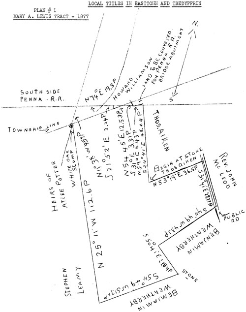
Plan #1 Mary A. Lewis Tract - 1877 It is planned to publish a number of these abstracts of title from time to time as they supply a background of our community from Colonial times with some record of the early settlers and those who followed them. Necessarily, they are condensed and will make dry reading and there are occasional omissions of portions considered immaterial here. Where title has passed by deed, statement of the form of conveyance is omitted. The abstracts are from data as it has come to hand and in many cases there has not been personal verification. This brief covers a tract of a little over thirty-eight acres laid out as shown in Plan 1, in 1877. It contains today a large part of the village of Berwyn south of the railroad. Plan #1 and page #1 of this brief are a description of the tract at that date. Then beginning with the original grant from William Penn of a larger tract which included the thirty-eight acre Lewis tract of 1877, we then show the various conveyances, etc., in order, down to and including the conveyance to Mrs. Lewis in 1877. Editor's Note: Please be aware that a "perch" is a unit of lineal measure and is equal to 5 1/2 yards or 16 1/2 feet. For a comparative chart showing perches and feet comparison, see: Vol. II, No.4, p. 99.) Beginning at a stone in line of Thomas Aiken's land, by same North 53 degrees 19 minutes East 36.5 perches to point in middle of public road in line of Rev. John McLeod's land, along middle of said road South 31 degrees 41 minutes East 28.77 perches to point in line of Benjamin Weatherby's land, by same: South 40 degrees 49 minutes West 43.1 perches, South 50 degrees 41 minutes East 21, 84 perches to stone and South 54 degrees 49 minutes West 51.72 perches to corner in line of Stephen Leamy's land, by same and land of heirs of Atlee Potter North 25 degrees 11 minutes West 112.6 perches to a white oak stump, North 11 degrees 38 minutes West 9,57 perches to a point on the South side of the Pennsylvania Railroad, along the same North 74 degrees East 19.8 perches to a point in line of Howard Williamson's land, by same South 21 degrees 52 minutes East 2.24 perches to a point a corner of said Williamson's land and in line dividing Easttown and Tredyffrin Townships, along said line North 54 degrees 45 minutes East 12,53 perches to point in said line and land about to be conveyed to Pennsylvania Railroad Co. for purpose of building an abutment for a bridge over said road, South 31 degrees East 3.31 perches, North 59 degrees East 6.43 perches to point in line of said Aiken's land, by same South 24 degrees 41 minutes East 48.24 perches to beginning. Containing by a survey thereof made February 10,1877 (Magnetic variation being 6 degrees 4 minutes West of the true meridian) 38 acres 53,49 perches conveyed to Mary A. Lewis in 1877. William Penn by his Commissioners of Property to William Wood. Patent for tract of land in Easttown of 250 acres. Not of record nor date recited. William Wood died in estate leaving a son Joseph and a daughter Susanna wife of George Simcock. 1690. Joseph Wood of Darby Township, recited in B-2-40 as yeoman, to George Simcock of the same place, carpenter, and Susanna his wife, by A-l-108, his interest in: Beginning at corner post of William Shardlow's land, South South East by same 196 perches, South 55 degrees West by a line of trees 202 perches to a corner post, North North West by a line of trees 196 perches and North 55 degrees East by a line of trees 202 perches to beginning. 250 acres.
Plan #2 1692. George Simcock of Philadelphia, merchant, and Susanna his wife, to Matthew Clemenson. Same. A-1-143. 1698. Matthew Clemson of Philadelphia, Merchant, or John Jones of Chester County, gentlemen. Same. A-l-213. 1701. John Jones to John Bentley. Same. Recited. 1703. John Bentley to William David. Same. Recited. 1704. William David to John Hugh. Same. Recited. 1705. John Hugh of Blockley Township, Philadelphia, husbandman, to Llewellyn David of Haverford Township, Sawyer. Same by B-2-40. 1708. Llewellyn David to Lewis Walker. Same. Recited. 1718. Lewis Walker of Valley Town. in the County of Chester, yeoman, and Mary his wife (Progenitors of the Walker family) to Robert Rogers late of Roxborough, husbandman. Same for 60 pounds. D--449. 1723. Robert Roger of East Town, yeoman, to Peter Elliott of Radnor Township, blacksmith. Same. Peter Elliott sold off 50 acres on the East to his son Morris and the remaining 200 acres were sold by Benjamin Davis, Sheriff, to John Llewellyn in 1759 on proceedings by John Fairlamb against James Elliott, Peter's son and executor. L-11-351. The will of Peter Elliott proved on Christmas in 1758. W. Bk. D vol. 4 p. 147, describes him as of Easttown and a blacksmith. It shows he left a wife Sarah, and had sons Morris and James and a daughter, Rachel Logan. He left his smith tools to James and his dwelling house and 200 acre plantation to his wife and the son James. Also as appears by deed B-9-140, he left his name to an old road extending southwardly from the Old Lancaster Road.* More definite location of the road and possible location of the blacksmith shop are left for a later paper. John Llewellyn died intestate leaving no widow, but sons John and David and a daughter Ann Llewellyn. * See Cockletown plan appearing in this issue of the Quarterly.
Plan #3 Llewellyn Tract 1779 1779. Release by John Llewellyn now of Tredyffrin and David Llewellyn and Elizabeth his wife to their sister Ann, recorded W-21-187, for the consideration of 2000 pounds, 66 1/4 acres of the 200 acre tract. (Plan #3) Beginning at a corner in the line of Tredyffrin Township and extending thence by the other part of the tract above described South 80 degrees East 24 perches to a post, South 35 1/2 degrees West 109 perches to a black oak tree, South 27 1/2 degrees East 40 perches to a post, South 54 degrees East 58 1/2 perches to a corner, South 52 degrees West 69 perches to a post in the line of land of Lewis Morris, by said Land North 27 1/2 degrees West 149 perches to a white oak in the township line and along the said line North 51 1/2 degrees East 148 perches to beginning. The large consideration is of interest and suggests the possibility of a thriving road house on the part of the tract omitted from the next deed in which the consideration appears normal. 1785. Ann Llewellyn to James Brown, by A2-25-463, for consideration of 165 pounds, 43 acres of the 66 1/4 acre tract. Beginning at a black oak in the line of land of David Llewellyn, thence by said land South 27 1/2 degrees East 40 perches to a post, South 54 degrees East . 58 1/2 perches to a corner, South 52 degrees West 69 perches to a post in the line of land of Lewis Morris, by said land North 27 1/2 degrees West 149 perches to black oak in the line of Tredyffrin Township, along said line North 5l 1/2 degrees East 42 perches to a post and by land of the said David Llewellyn South 27 1/2 degrees East 50 perches to beginning.
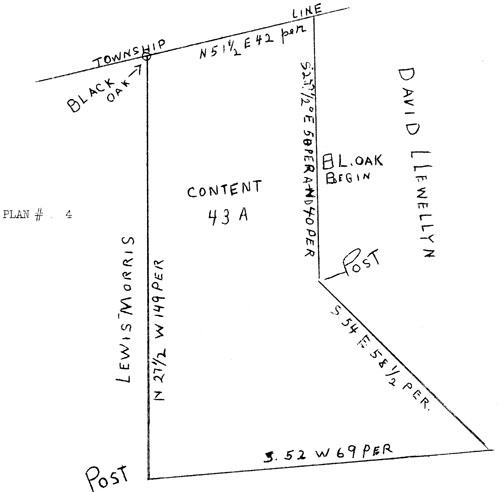
Plan #4 1805. James Brown and Rachel his wife to William Neill by A3-49-34, for 29 acres and 58 perches of the last tract in Easttown Township. Beginning at a line stone a corner of Griffith Weatherby's land, thence by land of Whitehead Weatherby North 50 degrees West 29.8 perches to a white oak, by land of James Morris North 28 1/2 degrees West 90.2 perches to a stone in the line of land of John Reese, on said line South 50 degrees 3l 1/2 minutes West 42 perches to a stone, by land of Martin Potter South 28 1/2 degrees East 112 perches to a stone, by land of Griffith Weatherby North 50 3/4 degrees East 50.7 perches to beginning.
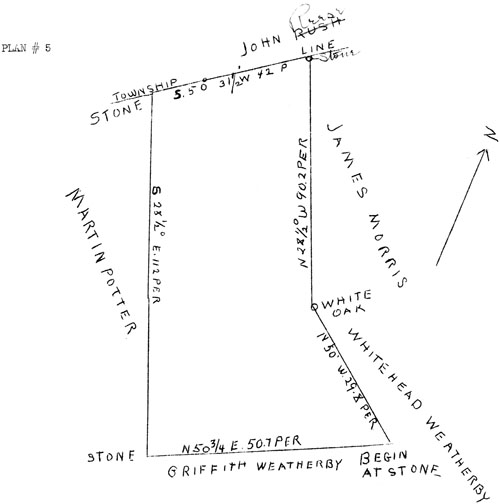
Plan #5 William Neill, recited in next deed as a farmer, died leaving a will proved April 7, 1820, W. Bk. N-13-217, appointing his wife Margaret and William Walley and Alexander Kennedy, Executors, with power of sale of real estate. After provision for his wife he provided: To my brother Adam's family, eight in number, to wit: William, Samuel, Alexander, sons, $200 each and to five daughters (without giving names) $l00 each, and to their mother Esther I allow the amount of legacy left by Mr. Thomas Neill for which I have Mr. Lewis Neills note for $216, for her use. To the Great Valley Meeting I give and bequeath 50 pounds, to Adam Neill's two sons and two daughters, in this country, I give and bequeath $50 each. To Isabella Gamble, daughter of James Gamble, $100. To his two sisters' families in Ireland the remainder of my property in equal parts, and should my estate not be sufficient to make this good, each and all of the legacies is to receive in proportion to the sums unto their respective names annexed, but my wife must go clear. 1822. Said Executors to Ann Whittle, by U-3-68-242, for the consideration of $2750, tracts in Easttown and Tredyffrin. Beginning at a white oak in the township line a corner of Joseph Potter's land, thence South 29 degrees East 112 degrees 2 perches, by land of Benjamin Weatherby North 51 degrees East 50 degrees 7 perches to a stone a corner of land of said Weatherby, North 54 1/2 degrees West 21 degrees 8 perches to a stake another corner of said Weatherby's ground, North 37 degrees East 43 degrees 1 perch to a stone in the middle of a lane or road, along the middle of said road North 35 1/2 degrees West 28 degrees 8 perches to another stone in the said road, by land of James Gamble South 49 1/2 degrees West 36 degrees 5 perches to a stake a corner of land of said Gamble, along said land North 28 1/2 degrees West 52 degrees 1 perch to a stone in the line of John Rees's land, along said line South 50 3/4 degrees West 19 degrees 4 perches to a stake in the hedge fence, along said hedge fence North 26 1/4 degrees West 19 degrees 7 perches to a Turnpike Road, along same South 76 degrees West 18 degrees 2 perches, by land of Joseph Patton South 15 degrees East 28 degrees 5 perches to beginning. Containing 40 acres, 2 roods and 14 perches.
1822. Ann Whittle to William Hyde. Same. In Trust for Ann Carter wife of Henry for life with power of appointment by will. Z3-72-163, repeating inaccuracies of description from preceding deed. Ann Carter by will and codicil proved 1875. W. Bk. Y-24-329, appointed William McClary of Philadelphia executor with power of sale. Her will shows Robert Whittle Carter and Henry Yeates Carter as sons, and Mary Ann, Sarah Sharp and Hannah Carter as daughters. 1877. William McClary Executor & c., to Mary A. Lewis for 38 acres 53.49 perches referred to on page #1 of this brief. Consideration $3400. V8-193-475. Following the ownership by Mrs. Lewis the tract was cut up for building purposes. The Easttown School Property, fronting on Lincoln Highway is now on the site of the old Carter apple orchard as recalled by F. L. Burns. (Continued in Part B) |