|
Home : Quarterly Archives : Volume 44 |
Tredyffrin Easttown Historical Society |
|
Source: Winter/Spring 2007 Volume 44 Numbers 1&2, Pages 6–8 The Early Days
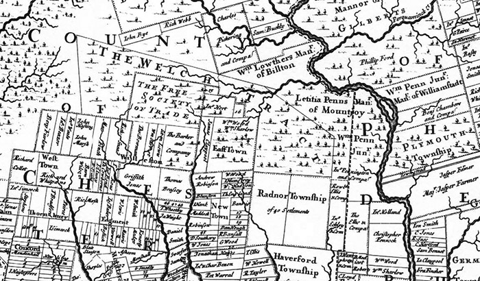
Part of Holme's 1687 map; Tredyffrin's location is under the word ‘tract' William Penn arrived on these shores in 1682 to form his colony of Pennsylvania. He quickly signed treaties with the Native Americans to purchase land that included the area that is now Tredyffrin Township. Little is known of native activity in the area, but a large number of arrowheads and other artifacts have been found along Valley Creek. There was also an Indian village at the mouth of Pickering Creek. The Indian Conestoga trail passed through the southern portion of the township. Although the Indians had probably burnt the area in the past (in order to help agriculture, and to improve hunting and visibility), the first white settlers were faced with an essentially virgin forest to clear. By an agreement that Penn made in England before sailing to America, a group of Welsh settlers were allocated a large tract west of the Schuylkill River. The Welsh settlers initially started to establish farms and clear land close to Philadelphia. The extent of the Welsh tract included essentially all of Tredyffrin. The township's northern boundary was also the boundary of the Welsh tract. Thomas Holmes' map shows that only a small part of the land in the township had been purchased by 1687. Penn gave land north of the township to his relatives in 1682. His daughter Laetitia was given the Manor of Mount Joy. The Manor had the Schuylkill River as its northern boundary, and Valley Creek as its western boundary. Margaret Lowther, Penn's sister, received the Manor of Bilton (named after a village near Hull, England) with a northern boundary of the Schuylkill, and an eastern boundary of Valley Creek. The southern boundary of the Manor of Bilton formed part of the northern boundary of Tredyffrin Township and runs along the ridge of the North Valley hills. The price of land in the colony was initially £5 per 100 acres, equivalent at today's prices to $110 an acre. There was also a yearly rent, called a quit-rent, of 1 shilling per 100 acres (equivalent to $110), although the payment of quit-rent was not systematically enforced. Penn's sons increased the costs to £15½ per 100 acres ($400 an acre) with a quit-rent of a half-penny per acre ($55 per 100 acres).
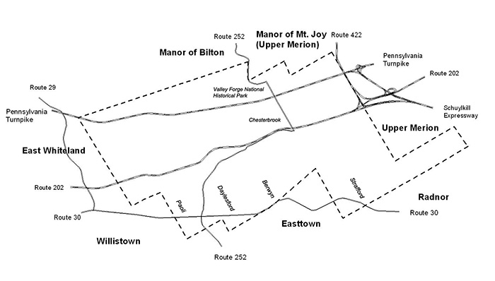
The Boundaries of Tredyffrin William Penn owned Pennsylvania. When a settler “purchased” land they were actually taking on a type of lease. Penn still owned the land. As a reminder the settler had to pay an annual quit-rent to the proprietor. Originally in England the quit-rent released the person from feudal services. Ownership of land became established around the time of the Revolutionary War. The Creation of the Township The map shows that the township is shaped very irregularly. Who could have designed such a shape? The answer to the question is that there was no design; the townships and manors around Tredyffrin were all in place before Tredyffrin was created. When it was organized the township filled in a blank space on the map. Radnor Township was created in 1684, and Willistown and Easttown in 1704. Together they defined the southern boundary of Tredyffrin. Merion Township (created in 1682) defined the eastern border (the township was split into Lower and Upper Merion in 1713), while Whiteland (1704) defined the western border. The only section of the boundaries not defined in 1707 was that with the land that later became Charlestown, and the Manor of Bilton defined that boundary. Tredyffrin means “the town or settlement (tre) in the valley (dyffrin)” in Welsh. Dyffrin has the connotation of a wide, lush valley. It is somewhat ironic that Tredyffrin for most of its history did not have a defined settlement that could be called a traditional town. That did not stop it thriving, so that it now has a greater population than any other township or borough in Chester County. The only records of the early existence of the township are court records confirming the appointment of township officers. The first such record for Tredyffrin is that of Thomas David being approved for the office of constable in 1708, so it is presumed that a meeting of the township voters took place in 1707 to agree on a nominee for the position. As well as performing court-ordered arrests, the constable was expected to keep the peace, and was also responsible for generating the tax list (a job for which he was paid 3 pence per pound of tax collected). Two other township positions existed in these early times. The Supervisor of Roads kept an eye on the state of the highways and organized their repair by the townspeople when necessary. The Overseers of the Poor were responsible for raising and distributing local taxes for the upkeep of the poor. They also had to ensure that non-resident poor did not become a burden on the township. These township positions were held by voters for a year on a rotating basis. Initially to be a voter you had to be a white male, over 21 years old, Christian (but not Catholic), and had to own at least 100 acres of land. The Early Settlers The earliest settler in Tredyffrin is generally considered to have been Lewis Walker, who moved into the township in 1698 or 1699. Initially he purchased 300 acres of land in 1702, but added to that so that he eventually owned 600 to 700 acres. Other sections of land in Tredyffrin were purchased before 1700 but there is no evidence of any settlement. The Walker family were significant landowners for many years. As well as giving their name to Walker Road there was also a Walker schoolhouse and New Centerville was originally known as Walkertown. Another large landowner in those early days was John Havard who purchased 800 acres in 1707. His property was centered in what is now Chesterbrook. The Havard family owned property in the area for over 150 years. By 1715 there were 22 landowners, mainly of Welsh extraction, and most of the best agricultural land was settled. The core of the township was solidifying. |
| Previous Article ⇐ ⇒ Next Article |