|
Source: Fall 2007 Volume 44 Number 4, Pages 180–184
7 Decades of Maps
1937-2007
Compiled by J. B. Post
Hint for using the map reference links: Using the “Back”
feature of your browser will return to the this page after you view the map(s).
The Delete (Mac OS) or Back Space (Windows) keys often perform this function.
You may need to scroll down on the destination page to see the map(s).
Page 180
The maps in the Quarterly reflect the production methods in use when an issue
is published. The maps published in the first 36 years (1937-1973) of the Tredyffrin
Easttown History Club Quarterly were mimeographed and drawn on a stencil. The
maps published in the 1978-2003 Tredyffrin Easttown History Club Quarterly were
produced by offset printing and are either originally drawn or traced from other
maps. From 2003 to the present, the maps published in both the Tredyffrin Easttown
History Club Quarterly (2003-2004) and the Tredyffrin Easttown History Quarterly
(2005 to the present) are prepared digitally; a variety of early and modern
maps have been digitized and reproduced.
A
Andrews' Property 1963. Vol. 43, No. 3 (Summer 2006) page 89
B
Bartram's Garden. Vol. 35, No. 1 (January 1997) page 38
Baseball Fields in Berwyn ... Between 1880 and 1920. Vol. 27, No. 2 (April 1989) page 54
Battle of the Clouds, September 16, 1777. Vol. 41, No. 2 (Spring 2004) page 45
Beaumont Property ... ca. 1893. Vol. 41, No. 1 (Winter 2004) page 7
Berwyn, Noting Historic Sites. Vol. 7, No. 3 (July 1952) page 59
Berwyn and Vicinity in the Early Eighties. Vol. 6 No. 2 (Annual 1945) pp.32-33
Berwyn Cemetery 1906. Vol. 39, No. 2 (April 2001) page 58
Berwyn in 1881. Vol. 26, No. 2 (April 1988) page 42
Berwyn Village Walk 1997. Vol. 35, No. 4 (October 1997) page 124
Berwyn Walking Tour 1999. Vol. 37, No. 4 (October 1999) page 112
Black Rock Dam. Vol. 29, No. 4 (October 1991) page 138
Blue Ball [both inns]. Vol. 2, No. 2 (April 1939) page 26
Blue Ball Tavern [both inns]. Vol. 43, No. 4 (Fall 2006) page 109
C
Cedar Hollow 1930's. Vol. 38, No. 2 (April 2000) pages 56-57
Cedar Hollow and Vicinity 1873. Vol. 38, No. 2 (April 2000) page 52
Cedar Hollow and Vicinity 1933. Vol. 38, No. 2 (April 2000) page 58
Cedar Hollow in the Late 1930's or Early 1940's. Vol. 42, No. 4 (Fall 2005) pages 124-125
Cedar Hollow Quarries. Vol. 42, No. 4 (Fall 2005) pages 119,131
Centreville [showing railroad trackage ca. 1899]. Vol. 43, No. 4 (Fall 2006) page 121
Charleston Harbor [SC] Confederate Defenses, April 12, 1861. Vol. 41, No. 4 (Fall 2004) page 123
Chester County ... 1780. v.27 n.2 cover (April 1989)
Chester County Roads [from the Thomas Scull map of 1770]. Vol. 24, No. 2 (April 1986) page 60
Chester Vallley Trail 2005. Vol. 43, No. 4 (Fall 2006) page 120
Chesterbrook Farm 1897. v.19 n.4 p.122 (Oct. 1981); Vol. 40, No. 3 (July 2003) page 79
Chesterbrook Farm, Berwyn. Vol. 34, No. 2 (April 1996) page 49
Christiana. Vol. 11, No. 1 (April 1960) page 15
Cockletown, Rough Sketch of Old. Vol. 1, No. 2 (January 1938) page 19
Conestoga Road North of Warren Tavern. Vol. 11, No. 2 (October 1960) page 45
Contention Lane [original survey]. Vol. 26, No. 4 (October 1988) page 152
Contention Lane [revised survey]. Vol. 26, No. 4 (October 1988) page 154
Conway's Brigade. Vol. 27, No. 1 (January 1989) cover, pages 30,32,34,36
Covered Bridges in Northeast Chester County. Vol. 36, No. 2 (April 1998) page 56
Page 181
D
[Daylesford Indicating Oak Knoll Estate]. Vol. 42, No. 1 (Winter 2005) page 27
Delaware Valley, Early Settlements in. Vol. 1, No. 5 (October 1938) page 9
Devault 1930's. Vol. 38, No. 2 (April 2000) page 46
Devault and Cedar Hollow [from Benjamin Smith's Map of the Early 1700's]. Vol. 38, No. 2 (April 2000) page 44
[Devereux School Sites in Berwyn 1963]. v.41 n.4 p.134 (Fall 2004); Vol. 43, No. 2 (Spring 2006) page 50
Devon. Vol. 29, No. 4 (October 1991) pages 143 [1881], 145 [1887], 147 [1897], 149 [1908]
Devon 1897. Vol. 30, No. 3 (July 1992) page 125
Devon 1912. Vol. 41, No. 4 (Fall 2004) pages 132-133
Devon Inn. Vol. 22, No. 4 (October 1984) page 137
Dutch and Swedish Settlements on the Delaware Before Penn – 1682. Vol. 1, No. 3 (April 1938) opposite page 1
E
Eagle School Rd., Plan Showing the Original. Vol. 4, No. 2 (April 1941) page 14
Easttown and Tredyffrin, Geological Map of. Vol. 7, No. 2 (December 1949) page 34
Easttown Township. Vol. 12, No. 2 (October 1962) page 33
Ehret Magnesia Manufacturing Company Plant. Vol. 43, No. 1 (Winter 2006) page 20
Elda Farm in 1912. Vol. 41, No. 4 (Fall 2004) page 111
F
Fatland Ford Road. Vol. 2, No. 1 (January 1939) page 6
Fort Fisher [NC]. Vol. 41, No. 4 (Fall 2004) page 127
[Fox hunt 1910]. Vol. 41, No. 2 (Spring 2004) page 66
G
Glassley. Vol. 5, No. 3 (Spring 1943) page 54
Glassley 1800. Vol. 5, No. 3 (Spring 1943) page 59
Glassley School. Vol. 1, No. 5 (October 1938) page 18
Great Valley Mills. Vol. 6, No. 1 (Annual 1944) page 2
Great Valley Township. Vol. 44, No. 1+2 (Winter/Spring 2007) page 71
[Great Valley Vanished Houses], East Whiteland, Tredyffrin. Vol. 35, No. 2 (April 1997) page 44
H
Holme's 1687 map. Vol. 44, No. 1+2 (Winter/Spring 2007) page 6
Howellville. Vol. 39, No. 3 (July 2002) page 76
Howellville 1883. Vol. 39, No. 3 (July 2002) page 87
Howellville 1912. v.39 n.3 p.88 (July 2002); Vol. 42, No. 3 (Summer 2005) page 97
Howellville 1963. Vol. 42, No. 3 (Summer 2005) page 100
Howellville 2005 [aerial image with property lines added]. v.42 n.3 back cover (Summer 2005)
Hunter, Stephen D. Tract. Vol. 3, No. 2 (April 1940) page 45
I
Iron Mines [in Tredyffrin] 1873. Vol. 27, No. 4 (October 1989) page 141
Page 182
J – K
Jarman's Mill Road. Vol.6 No.1 (Annual 1944) pages 14-15
Jenkins Arboretum. Vol. 25, No. 4 (October 1987) page 123
L
Lancaster Avenue, Berwyn ca. 1920. Vol. 15, No. 4 (October 1970) page 73
Land Titles in Easttown and Tredyffrin. Vol. 1, No. 2 (January 1938) pages 11,13,14,15,16,18 ;
• Vol. 1, No. 3 (April 1938) page 9;
• Vol. 1, No. 4 (July 1938) page 26;
• Vol. 1, No. 5 (October 1938) page 23;
• Vol. 2, No. 1 (January 1939) page 17;
• Vol. 2, No. 2 (April 1939) page 38;
• Vol. 3, No. 2 (April 1940) page 45;
• Vol. 4, No. 1 (January 1941) page 12
[Leopard Road from Berwyn to Leopard]. Vol. 10, No. 4 (October 1959) page 70
Lewis, Mary A. Tract – 1877. v.1 n.2 p.11 (January 1938); Vol. 1, No. 3 (April 1938) page 9
Lincoln Highway. Vol. 35, No. 1 (January 1997) page 34
M
Massey [Thomas] House. Vol. 34, No. 4 (October 1996) page 161
Mid-County Expressway ... 1957. Vol. 30, No. 2 (April 1992) page 83
Moore Hall. Vol. 36, No. 4 (October 1998) page 131
N
New Centerville. Vol. 13, No. 1 (April 1964) page 18
New Centerville [showing the Valley Forge Music Fair]. Vol. 43, No. 3 (Summer 2006) page 79
O
Oak Knoll. Vol. 43, No. 2 (Spring 2006) page 75
Old Eagle School, Location of. Vol. 4, No. 2 (April 1941) page 16
Old Forge Crossing. Vol. 37, No. 3 (July 1999) page 85
Old Lancaster or Conestoga Rd. Vol. 3, No. 1 (January 1940) pages 13,14,15,17
• Vol. 5, No. 2 (Autumn 1942) pages 32,34
[Old Lancaster Road]. Vol. 2, No. 4 (October 1939) page 98,100,101
Old Lancaster Road ... through Sitersville in 1806. Vol. 5, No. 2 (Autumn 1942) page 34
P
Panama. Vol. 3, No. 3 (July 1940) page 52
Panama Vol. 26, No. 3 (July 1988) page 106
Paoli 1897. Vol. 40, No. 2 (April 2003) page 64
Paoli 1912. v.40 n.4 p.125 (October 2003); Vol. 43, No. 4 (Fall 2006) page 113
Paoli 1963. Vol. 43, No. 4 (Fall 2006) page 116
Paoli Massacre. Vol. 1, No. 1 (October 1937) page 5
Paoli Parade Grounds. Vol. 4, No. 4 (October 1941) page 81
Pennsylvania Railroad Electrification Map. Vol. 42, No. 2 (Spring 2005) page 38
Petersburg [VA] Mine Explosion, July 30, 1864. Vol. 41, No. 4 (Fall 2004) page 124
Phoenixville, Valley Forge, & Strafford Railway, proposed routes. Vol. 44, No. 1+2 (Winter/Spring 2007) page 50
Port Kennedy. Vol. 43, No. 1 (Winter 2006) pages 13,16,17,19
Potts', David & William Dewees' Forges. Vol. 41, No. 3 (Summer 2004) page 79
Page 183
Q – R
[Railroads, Model] The Layout of the Pennsylvania Live Steamers in Ken Souser's Orchard. Vol. 18, No. 2 (April 1980) page 56
Railroads in Tredyffrin. Vol. 44, No. 1+2 (Winter/Spring 2007) page 46
Railroads of Chester County. Vol. 7, No. 4 (February 1953) pages 91-92
Reeseville Station Tract 1859. Vol. 4, No. 1 (January 1941) page 12
Revolutonary War, American Outposts on the West Side of the Schuylkill [1777-78]. v.2 n.3 pp.58, 62, 65, 67, 71 (July 1939) [maps by S. Paul Teamer]
Revolutionary War Road Map. Vol. 44, No. 1+2 (Winter/Spring 2007) page 9
Roads [original main]. Vol. 9, No. 2 (October 1956) page 48
[Roads] Our First Road Map? Vol. 30, No. 1 (January 1992) page 12
S
Spread Eagle Village 1800-1860. Vol. 36, No. 3 (July 1998) page 89
Strafford 1965. Vol. 35, No. 2 (April 1997) page 75
Strafford Station Neighborhood. Vol. 38, No. 1 (January 2000) page 6
Strafford Walking Tour ... 2000. Vol. 39, No. 1 (January 2001) page 30
Swedesford Road, Plan approved by the Provincial Council in 1725. Vol. 13, No. 1 (April 1964) page 9
T
Theodore Ricks Memorial Cemetery. Vol. 26, No. 1 (January 1988) page 14
Townships in Jointure. Vol. 8, No. 4 (October 1955) page 105
Tredyffrin 1847. Vol. 39, No. 3 (July 2002) page 87
Tredyffrin, British Army Encampment in, ... 1777. Vol. 1, No. 1 (October 1937) page 2
Tredyffrin and Easttown. Vol. 7, No. 1 (December 1948) page 15
Tredyffrin and its Surrounding Area, 1792. Vol. 44, No. 1+2 (Winter/Spring 2007) page 3
Tredyffrin Boundaries. Vol. 44, No. 1+2 (Winter/Spring 2007) page 7
[Tredyffrin] British Camp at Trudruffrin [1777]. v.24 n.4 p.147 (October 1986); Vol. 41, No. 2 (Spring 2004) page 49
Tredyffrin Camp 1777. Vol. 3, No. 2 (April 1940) page 33
Tredyfrrin Golf Course.Vol. 42, No. 3 (Summer 2005) front cover
Tredyffrin Landowners. Vol. 22, No. 1 (January 1984) page 20
Tredyffrin Township. Vol. 32, No. 1 (January 1994) page 9
Tredyffrin Township 1829. Vol. 43, No. 3 (Summer 2006) page 92
Tredyffrin Township, Chester County Nature Preserves. Vol. 29, No. 3 (July 1991) page 126
Tredyffrin Township, Early Grants and Patents, 1681-1760 [map by Benjamin H. Smith 1820, redrawn by R. L. Ward 1982]. Vol. 20, No. 2 (April 1982) page 42;
• Vol. 43, No. 3 (Summer 2006) page 90
Tredyffrin Township, Field Trip to Generals' Quarters. Vol. 28, No. 1 (January 1990) page 4
Tredyffrin Township, Open Space in. Vol. 44, No. 1+2 (Winter/Spring 2007) page 78
Tredyffrin Township, Possible Prime Industrial Areas ... 1958. Vol. 32, No. 1 (January 1994) page 5
Turnpike Proposed Extensions, 1948. Vol. 44, No. 1+2 (Winter/Spring 2007) page 11
U
Underground Railroad in Chester County. Vol. 12, No. 2 (October 1962) page 42
University [of Pennsylvania] Campus at Valley Forge. Vol. 24, No. 1 (January 1986) page 34
V
Page 184
Valley Forge. Vol. 8, No. 3 (April 1955) page 61
Valley Forge [topography]. Vol. 43, No. 4 (Fall 2006) page 130
Valley Forge, Map of Officers' Quarters. Vol. 8, No. 2 (April 1954) page 48
Valley Forge Area. Vol. 43, No. 4 (Fall 2006) page 128
[Valley Forge] British Encampment and Generals' Quarters ... 1777. Vol. 44, No. 1+2 (Winter/Spring 2007) page 23
Valley Forge Encampment ... 1778. Vol. 1, No. 2 (January 1938) inside front cover
Valley Forge Encampment, Officer's Quarters. Vol. 1, No. 5 (October 1938) page 2
[Valley Forge] Generals' Quarters and Picket Posts. Vol. 44, No. 1+2 (Winter/Spring 2007) page 25
Valley Forge Village 1883. v.41 n.3 p.81 (Summer 2004); Vol. 43, No. 4 (Fall 2006) page 131
Valley Forge Village and Industry around 1890. [lithographed view] Vol. 41, No. 3 (Summer 2004) cover
Valley Friends' Meetinghouse and Cemetary. Vol. 4, No. 3 (July 1941) page 68
Valley Friends' Meetinghouse and School. Vol. 1, No. 4 (July 1938) page 23
Valley Store and the Surrounding Neighborhood ... Late 1930's and Early 1940's. Vol. 36, No. 2 (April 1998) page 36
Van Leer [Isaac] Estate Showing Locations of Cabin Tract. Vol. 21, No. 3 (July 1983) page 94
W
Warner Company Lime Plants in Chester Valley 1930. Vol. 37, No. 1 (January 1999) page 4
Waterloo Mills Preserve. v.37 n.2 cover (April 1999)
Waterloo Road 1803. Vol.6 No.1 (Annual 1944) page 21
Wayne's Last Great Service, Opening the Western Gateway. Vol. 2, No. 2 (April 1939) page 46
Waynesborough 1950. Vol. 39, No. 2 (April 2001) page 67
Welsh Line Road from Conestoga Rd. to Above St. David's Church. Vol. 2, No. 1 (January 1939) page 8
Welsh Line Road from Yellow Springs Rd. to Conestoga Rd. Vol. 2, No. 1 (January 1939) page 7
Welsh Tract – 1682-4. v.2 n.1 cover (January 1939); Vol. 2, No. 1 (January 1939) page 20
Welsh Tract as shown on the 1687 Holmes map. Vol. 20, No. 1 (January 1982) page 6
Welsh Tract ... in Easttown Twp. Vol. 7, No. 3 (July 1952) page 50
Whitemarsh Camp ... 1777. Vol. 1, No. 2 (January 1938) page 4
Wilson Farm Park, October 2, 2004. Vol.41 N.4 (Fall 2004) back cover
X – Y – Z
Yellow Springs Road 1950. Vol. 42, No. 4 (Fall 2004) page 110
Yellow Springs Road Alignments. Vol. 42, No. 4 (Fall 2005) page 107
Yohn Farm in Chesterbrook 1963. Vol. 44, No. 3 (Summer 2007) page 107
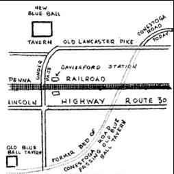
This map, showing the old Blue Ball Tavern and the new Blue Ball Tavern, is
a good example of how maps can clarify locations. The distinction between these
two Taverns, also called Inns, and both of which are still standing, is a source
of perennial confusion among local residents. This was first brought about when
the roads were realigned in 1793 and the tavern was relocated to be closer to
the new road. When the railroad was put in, in the 1830s, traffic on the new
route of the road declined and the tavern at the new site again lost a good
business location. Tredyffrin Easttown History Club Quarterly, vol. 2, no.
2 (April 1939), p. 26.
|